
Polblue Swamp Track
Barrington Tops National Park


Menu
A lovely walk around a Swamp that drains into streams throughout the Barrington Tops National Park bringing nourishment to the flora and fauna downstream.

Getting there
On the western end of the Barrington Forest Road between Scone and Gloucester. The Camping area and picnic area are on your left if coming from Gloucester.
Maps
Which maps cover the area?
Route/Trail notes
This walk begins at the Polblue Camping Area and circles the Swamp in an anti clockwise direction. It crosses a number of bridges over streets that either drain from or feed into the Swamp. There are interpretive signs along the way that tell about the flora and fauna of the Swamp. When you reach the picnic area, the track seems to disappear for a minute. Keep following close to the swamp and you will see it pick up again and take you over another bridge over Polblue Creek before returning to the camping area.
Permits/Costs
No cost unless camping
How can I find more info? Any guide books?
GPS Tracks
- No GPS available for this walk yet.
 3
3 1
1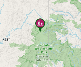
Comments