
Polblue Falls
Barrington Tops National Park


Menu
A short walk in the northern section of Barrington Tops National Park to a lookout over the picturesque Polblue Falls.

Getting there
On the western end of the Barrington Forest Road between Scone and Gloucester, take Tubrabucca Rd to the north. It is to the west the the Firs picnic area. Polblue Swamp Picnic Area is after Horse Swamp Camping Area. Don't get confused by The Falls Rd. This isn't the correct road to get you there. If you see this sign, keep going.
Maps
Which maps cover the area?
Route/Trail notes
From the apolblue Swamp picnic area, follow the path on the right hand side of the picnic area. The path isn't marked. After a short distance you will see a smaller side track to the left. This track will take you to the bottom of the Falls. The track on the right goes to a lookout over the Falls. Taking both tracks and returning is about 400m.
Permits/Costs
No cost
Other References
How can I find more info? Any guide books?
GPS Tracks
- No GPS available for this walk yet.
 400
400 20
20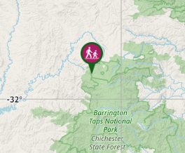
Comments