
Werribee Gorge Short Circuit Track
Werribee Gorge State Park


Menu
A shorter form of the Werribee Gorge Circuit Walk.
Lookouts
Picnic Facilities

Getting there
Follow the Western Freeway (M8) past Bacchus Marsh and take the Myrniong exit. Turn on to Pentland Hills Road then right onto Myers Road. Follow this to either the Quarry Picnic Area or the Meikles Point Picnic Area.
Maps
Vicmap 1:25000 Ingliston 7722-1-3 or Vicmap 1:30000 7722-1-3-1
Route/Trail notes
The track should be easy to follow, just make sure to divert from the Werribee Gorge Circuit near Eastern Viewpoint.
Other References
http://parkweb.vic.gov.au/explore/parks/werribee-gorge-state-park
GPS Tracks
- No GPS available for this walk yet.
 5
5 2
2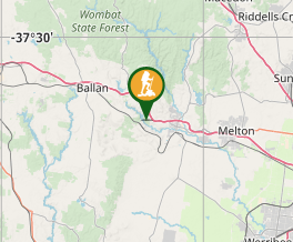
Comments
Nobody has commented on this walk yet. If you've done it then tick it off and add a comment.