
Centenary Walk
Werribee Gorge State Park


Menu
Walk through to the James Whyte Island Reserve for panoramic views over Werribee Gorge and beyond.
Lookouts
Picnic Facilities

Getting there
Follow the Western Freeway (M8) past Bacchus Marsh and take the Myrniong exit. Turn on to Pentland Hills Road then right onto Myers Road. Follow this to the Quarry Picnic Area.
Maps
Vicmap 1:25000 Ingliston 7722-1-3 or Vicmap 1:30000 7722-1-3-1
Route/Trail notes
From the Quarry Picnic Area follow the Werribee Gorge Circuit Walk. The walk diverges and passes through open woodlands to a bridge aross Myrniong Creek. The final climb is very steep to the lookout.
Other References
GPS Tracks
- No GPS available for this walk yet.
 4
4 2.5
2.5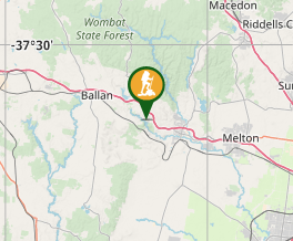
Comments
Nobody has commented on this walk yet. If you've done it then tick it off and add a comment.