
Menu
Suggested searches
Your search found 2444 results...

 4.4
km
4.4
km
 3
hrs
3
hrs
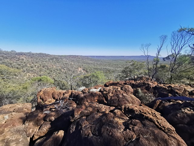
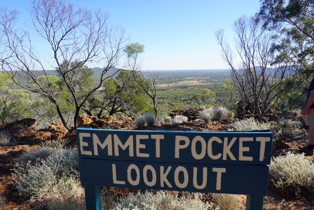
Emmet Pocket
Idalia National Park
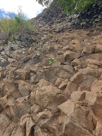
Emmet Pock is in Idalia National park whick is 113kms south west of Blackall. This is a difficult walk with steep grades up and down the gorge walls but is well worth the effort. I found walking poles were worth there weight in gold. There are four walks to do while in this park all easier than this one.
Emmet Pocket walk—4.4km return (Allow 2–3hrs)
Grade 5
Beginning at Emmet Pocket lookout this steep meandering track leads into a gorge where the plains of the outback spread out before you—laid out like a map. Trees mark the waterways that stretch from rocks to river channels.
 2
km
1
hr
2
km
1
hr
Scrammy Lookout
Central Queensland
This walk is part of the Bladensburg National Park and allows you see the big sky, and lots of sand and very little vegetation sandstone ranges and flat top mesas... Skull Hole, is a waterhole in the park where an aboriginal massacre known as the Bladensburg Massacre took place
 19.5
km
6
hrs
19.5
km
6
hrs
Grand Canyon Rim Walk
United States of America
The highlight of course is the Grand Canyon, nothing you have ever seen can prepare you for how big it really is, the path is mostly paved with some gravel sections, and views up to 40miles to the other side of the canyon. There is a bus for the return journey and planning to be on the rim at sunset is a must.
18
km
2
days
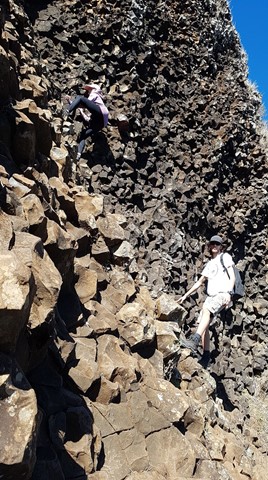
Spicers Peak West
Main Range National Park
We have ventured to this part a couple of times now and still find it a challenge worth doing.
Nothing massively hard in the climb to the top except when we last did the climb and indeed every time before that we were carrying way too much weight.
We followed the old track up from Governors Chair lookout for about 3.5km until seeing a clearing on the left hand side of the road.
From there we left the road to find the bigger of the the spurs that lead to the main ridge. The climb up the spur did get a bit steep towards the ridge and was quite soft dirt under foot so takes a bit of time to get through. We like to do things the hard way ...(:
Once on the ridge the route does get a bit easier for a while with a gental climb for a couple of hundred meters.
From there it gets steeper and rockier with some minor obstacles and scrambling.
Camping before reaching the overgrown part on a grassy outcrop, we have an awesome view of the Darling Downs district and the sun set.
As much as like new places, this mountain keeps me coming back for more.
Maybe it's because it's not as popular as other walks near by.
4.6
km
return
2.5
hrs
Cedar Grove Hiking Trail
Amamoor State Forest
4.6km of rain forest. The first kilometre is a rise of 327mtrs above sea-level, which makes that about a 25% incline. The rest is a gentle downhill slope that flattens out to the forest floor.
 5.5
km
return
2.75
hrs
5.5
km
return
2.75
hrs
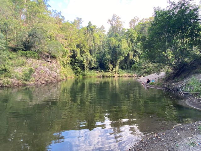
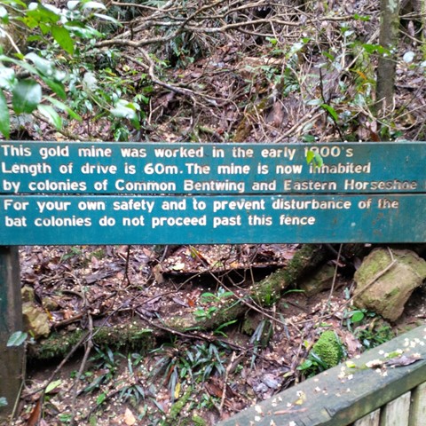
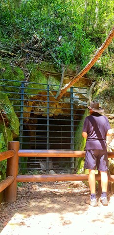
Gold Mine
Conondale National Park
This 5.5km walk is a pleasant and easy walk, with slight inclines and easy walking. It runs alongside Booloumba Creek and winds its way up to the Gold Mine. The main track is through sub-tropical rainforest and wet sclerophyll forest.
 650
m
return
15
mins
650
m
return
15
mins
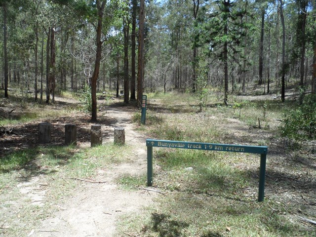
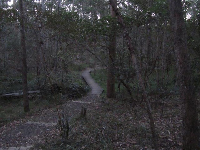
Bunyaville Conservation Park
South East Queensland
Featuring a boardwalk and interpretive signs, this walking track starts and finishes at the northern end of the day-use area. Meander through dry open forest and discover the diverse range of eucalyptus species found in this peaceful reserve. Koalas are occasionally seen here—look out for their grey bodies high in the trees.
 10.9
km
3
hrs
10.9
km
3
hrs
James Mcane Lookout to Mothar Mtn Rock pools
Woondum National Park
This walk will take you from the James Mcane Lookout just out of Cooran to the Mothar Mtn Rock pools day use area. The track I took is mainly a 4WD track but in the whole day I saw 1 4X4. The track winds its way over the Mothar Mtn range in the Woondum NP, and the walking is not to hard with gentle slopes going up and down. This walk however is listed as 1 way. If you wish to return you must go back the way you came, or if enough with transport a vehicle can be left at either end to ferry you back. The return trip by foot would be 21.8klms back to the lookout.
2
km
return
2
hrs
Table Top Loop
Toowoomba
Table Top mountain on the edge of Toowoomba, provides views of the Lockyer Valley and surround. The climb itself can be quite demanding with a lot of large steps over the Camel's Hump and a scramble just before the summit. But the reward at the top, with a circuit all the way around, provides a spectacular vista.
Table Top is an area of high significance to the Traditional Owners, recognised in the Aboriginal Cultural Heritage Register and protected under the Aboriginal Cultural Heritage Act 2003. You are respectfully requested to consider your decision to climb this mountain.
 2
days
2
days
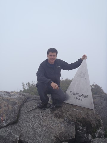
Mt Fansipan (Phan Xi Pang)
Vietnam
Fansipan is a mountain in Vietnam, the highest in Indochina (comprising Vietnam, Laos, and Cambodia), at 3,143 metres (10,312 ft). It is located in the Lào Cai province of Northwest Vietnam, 9 km southwest of Sa Pa Township in the Hoang Lien Son mountain range.
Fansipan is dubbed "the Roof of Indochina"; it is to be approved as one of the very few ecotourist spots of Vietnam, with about 2,024 floral varieties and 327 faunal species.[