


 15.5
15.5 4.5
4.5- Mt Blaine Summit Trail (Ipswich - Flinders Goolman Conservation Estate)
- Mt Blaine Base Trail (Ipswich - Flinders Goolman Conservation Estate)
- Sandy Creek Track (Ipswich - Flinders Goolman Conservation Estate)
- Flinders Peak (Ipswich - Flinders Goolman Conservation Estate)
- Flinder’s Peak Circuit - approach from South (Ipswich - Flinders Goolman Conservation Estate)
Sandy Creek Central Ridge Track
Ipswich - Flinders Goolman Conservation Estate
Menu

This is a longer walk (hence the "Hard" grading) that is not overly difficult, and gives you a completely different view of Flinders Peak. The track does have a few very steep sections and is not well marked, with some of the markers giving you a very vague indication of which way to go.
Bird Watching
Picnic Facilities
BBQ
Toilets
Navigation Required
No Dogs Permitted
Horses Permitted
Cycling Permitted
Eucalypt Forest
485m
Maximum Elevation
390m
Total Climb
Getting there:
The walk starts at the Flinders Plum Conservation Park. To get to Flinders Plum follow the Ipswich Boonah Rd to the turn off on your left just before you enter Peaks Crossing. The road has 6 Klm of gravel road to get into the park. 2WD drive access is OK normally, except for heavy rain periods when some of the creek crossings may flood and become very muddy and slippery.
Maps:
Which maps cover the area?
Route/Trail notes:
The Sandy Creek track is well signed and well used and the Central Ridge track joins it at the first major fork in the track (about 1.5K from the car park). Take the first fork right here and ignore the larger track now running down and below you on your left, which is the continuation of the Sandy Creek track. After climbing gradually up, you should come shortly to another fork in the track with a large shady tree with a large seat in front of it. There is also a sign post here stating this is the start of the Central Ridge Track. Take the right fork again and the track now heads seriously uphill. From here follow the main track marked as CRT or SCRT. This track does a large dog leg loop and takes you around to the backside of Flinders Peak and eventually ends at a rough bush car park on Mt Elliot Rd. This is your turn around point and you head back the way you came. There are quite a few places on the Central Ridge track where you have phone reception so you can use phone maps to help navigate. There are a few other tracks that run off the Central Ridge track at various places, so navigation can be a little tricky. Again phone maps or a GPS will see you through.
Permits/Costs:
No permit required, entry is free.
Other References/Comments:
How can I find more info? Any guide books?
GPS Tracks
- No GPS available for this walk yet.
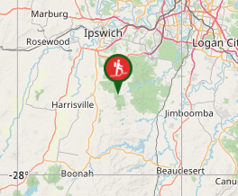
Where
Click here to load this map.
Comments