South Kobble bush camp walk

D'Aguilar National Park

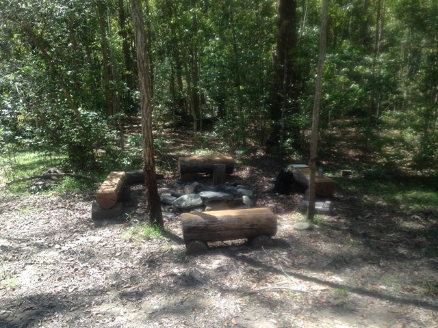
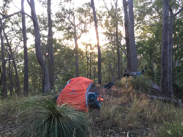
Remote bush camping in open forest beside Kobble Creek.

Getting there

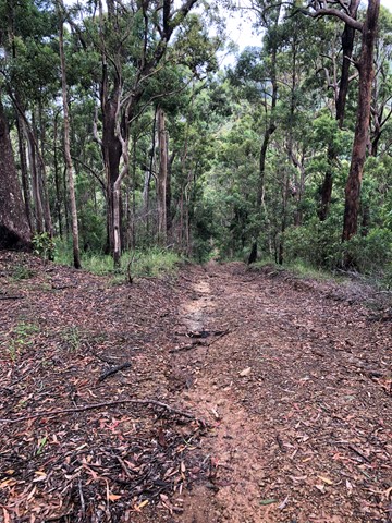
From Mount Glorious Road, this campsite is accessed via the Lepidozamia track. The Lepidozamia track entrance is an hour drive from Walkabout Creek in The Gap.

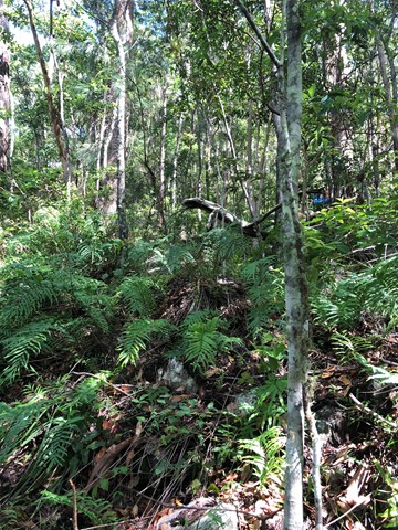
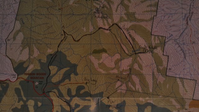
The campsite's only access is by walking along unmarked trails through steep terrain. You will need to be physically fit, have bushwalking and navigation skills, and have an emergency plan in place with a responsible friend or family member. A topographic map is required to find the campsite - map grid reference: 789 819.


Maps

 Brisbane Forest Park Information map

Route/Trail notes

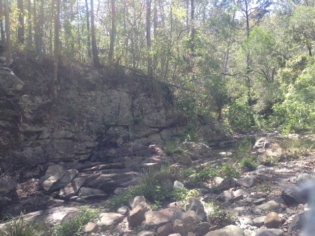
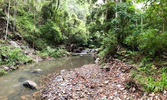
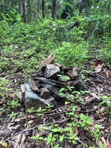
 Follow the Lepidozamia Track for about 2km and take the 4wd track to the right just before the Lepidozamia Track divides. Follow this track steeply downhill for about 1.5km and turn off just before the track veers north. Climb the knoll on the right which is marked as 560. at the top follow a rough indistinct trail south and downhill till you reach the creek above a waterfall, descend this waterfall by a faint track on the northside. Keep rock hopping and following the creek downstream to a meeting of another major stream from the south( on the left). A large pool was there when I walked this. There are camp sites here. Follow this stream south through a number of high walled areas and waterfalls. To return simply retrace your steps. I did mark the trail coming down the knoll but removed it on my exit.

Permits/Costs

 $5 permit fee

Other References

 Nil

Comments

Camp site is not marked on maps correctly. Below are the exact coordinates of the campsite entrance, position set by QLD Parks camp sign post.

UTM coordinates of campsite entrance: 56J 479081E 6981961N

Decimals / Degrees coordinates of campsite entrance: -27.28517, 152.78862

Doug Steindl on 21 May, 2023

Managed to find the site after a couple of corrections, initially we were too far east and came down the wrong ridge. Phone reception was sporadic so having a topographic map and compass was very useful. There are tracks at times but you can't always rely on them to take you in the right direction! Camp site was great with plenty of trees to hang a hammock and a lovely wide pool in the creek - fairly clean, but we did see pigs in the area so treat before drinking. Strenuous climb out the next day, nearly all uphill, which I wouldn't want to tackle in Summer.

Pendinghiker on 21 Aug, 2021

attempted this many times. and been studying this route for years. I did not find the campsite. I half expected it to be close by the creek. according to my GPS, I was at the correct location However the camp seemed to be direct atop a tall ridgeline south side of the creek. I was way too exhausted to bother climbing that ridge at the end of what was a tough day, for me. If you watch my video you may be able to tell where I should've looked.
cheers Gizmo's Adventures.

gizmobazz on 25 Apr, 2021

Did this as part of a large loop including North Kobble and Middle Kobble campsites. Enjoyable though it was it was quite a tough run doing all three in one day.

The access track to South Cobble starts from the fire trail about 600m south of Middle Kobble campsite. At time of writing there is a small cairn and band of pink tape marking the spot. A small but defined path leads you eastwards about 350m up a hillock before descending to the northeast. When you crest a second hillock about another 350m along, the path splits. I took the way going southeast (directly towards the campsite). Not very far along the path becomes intermittent after which I lost it. I descended a steep slope into the valley, utilising animal trails where I could, and even an old logging trail briefly, before I intersected a path again. I followed it down a steep earthy spur but lost it once more. After this I just bush bashed into the creek.

I emerged into the creek just east of the confluence of Kobble Creek and Musket Creek (it's the last confluence before the campsite, about 400m west of it). Following the creek was easy going and the campsite is marked on a small path leading off the north side of the creek. A few log benches are there if you fancy a sit down.

From here there are several ways out but I chose to follow Kobble Creek west and ascend up its South Branch. This was the highlight of the trip for me and well worth doing. It's worth noting the creek was dry when I was there, and it may not be possible to do this during wetter times.

Starting from the campground walk west until you get to the first confluence (Kobble and Musket). Take the branch to the right (Kobble, the more northerly) and continue on. Initially the creek is largely walkable but then becomes progressively more 'rock hoppery'. About half a kilometre west of the confluence you come to a waterfall that must either be climbed or circumvented (the creek here has steep sides so circumventing would require some forethought). The waterfall itself is not a difficult climb however reaching its base is tricky because of a large pool at its foot. I opted to shimmy along a small ledge to its left side, however it should be noted the ledge was narrow, slippery, and directly above rock filled water - an unpleasant combination.

Beyond, the rocks in the creek grow larger and ascend more steeply, requiring an increasing amount of scrambling and in places some non technical climbing. A few hundred metres beyond, a second waterfall also needs to be ascended. It's possible you could circumvent this one more easily however I again opted to climb directly up it. Some level of climbing skill is needed to do so.

Above, the creek becomes narrower and ascends more steeply until you reach a second confluence. Again, remaining to the right (the more northerly) branch, I followed Kobble Creek about another 150m where I came to a third confluence. This is where I turned southwards, taking the way on the left into the Kobble Creek South Branch. At time of writing there was a pink band on a tree marking this point.

Not far into this creek there are two trails that lead up southwards (on your left) onto the ridge line above. Both points are marked by pink ribbon, at time of writing. I took the second path, about 250m from the confluence (third pink ribbon in). The initial ascent is steep and slippery but the path is easy enough to follow, albeit narrow and twisting. Eventually the ascent shallows and you intersect the Piper Comanche/Mt. D'Aguilar access trail. Turn right here and follow it westwards 1200m or so back to the car park.

MDWL on 3 Dec, 2020

a more direct return is to go up the creek for about 10 min from the camp. just after a big flat left creek branch, go up the long spur heading SW. there's a path on either side of a ditch that runs the whole way up the spur. gradually heading more west you reach a knoll, height not marked on the map but 675m. from here there's a good path west that comes out 50m past the lepidozamia locked gate. this knoll is a common marker point for walks in the 1990s people's guide to SE qld bushwalks. eg. a path south from the knoll comes to a cairn where there's a path left to the piper comanche wreck. to avoid lantana when approaching the 675m knoll from south kobble, try to intercept an old cut logging track that runs just north of the knoll. but even if you get distracted by pig tracks and end up in some lantana it's not too bad. just head for the 675m knoll. i've done this route a few times. it makes south kobble bush camp into a nice circuit walk.

guy taking his kids on 2 Feb, 2020

The path NE from the 560 knoll is definitely better. After the saddle head east. Follow the ridge that gradually bends south, to meet the creek directly at the bushcamp. Stay on the crest of this spur all the way down. If you head south too early you end up in lantana. The correct (if you want an easy day) more easterly ridge is fairly open. If you end up in lantana, the feeder creek running SE to meet S kobbold creek at the bushcamp is also an OK route if it’s dry. The camp is on the north bank of S kobbold creek, just east of a small cliff. It’s a nice spot. About 2h each way.
As these are all old logging paths, look out for old sawn tree stumps as indicators that you’re going the right way. The pink tape is less useful - more like annoying litter. The path is easy to follow for most of the way.

guy taking his kids on 27 Jul, 2019

A great adventure despite not finding the camp.
The walk from the start of the Lepidozamia track to Middle Kobble Break the turn off and to knoll 560 was easy (keep an eye out for the rock cairn on the right for the correct point to leave the Middle Kobble Break, there was pink tape marking the path all the way to the knoll 560 summit).
We then followed the pink tape marked trail down from the knoll heading north east for a few hundred metres and then took a right turn where the path forked to head more southward. We continued following the pink tape which eventually had us heading north easterly again and thought we’d gone too far and so decided to venture south down a gully with GPS indicating the camp was directly in front of us down that gully where I expect it would meet the main creek (N.B. I think this is where we went wrong and that we should have turned more south sooner to come down a more western gulley towards Kobble Creek - we must have missed a feint trail along the way). The rock hopping, overgrown and sometimes loose nature of the rocks in the gully made it very difficult with our overnight packs and we bailed out and scrambled up to instead camp on a flat spot on the spur overlooking the valley. The south Kobble camp would have been directly below us by our reckoning. Unsure of water supply in the creek - the gully leading towards it was bone dry.
Next morning, we pushed directly uphill to the ridgeline, bush bashed our way right/northward along the ridge through thick grass trees and came upon the pink marked trail again that led us nicely around the ridgeline and up to knoll 560 again for the return walk home along the fire breaks.
Despite not reaching the intended camp, we enjoyed a great night out with fantastic star gazing, a few little bats and gliders calling out just after dusk and the kookaburras woke us promptly at 4.40am in time to prep a coffee and watch the sun rise from behind the mountains across the valley.

Elise & Mark on 26 Jan, 2019

Completed this on 2&3 January 2018 with an overnight camp at the creek. Very hot, humid & we experienced thunderstorms & rain. I agree with Moocattle's post on 11-6-16 expanding with the following. The walk from the start of the Lepidozamia track to the turn off to knoll 560 is about 4km and is along a wide 4wd/fire trail & is mostly down hill to this point. A small rock cairn has been placed at the side of the fire trail which indicates the location of the path uphill to Knoll 560. From the knoll head North-East along a fairly well marked track. Approximately 300m from the knoll the track divides - one continuing north-east and another south east down the hill towards the creek. We took the south branch (but possibly a better route would be to continue North east??) and followed the top of the spur in a South Easterly direction down to the creek. The terrain is very steep but the vegetation fairly easy to navigate most of the way until approx 30m from the creek where it is very thick and hard to get through. We arrived at the creek at what we thought were the correct GPS coordinates however were unable to locate the campsite. I believe that were about 100m West of the actual campsite (where Moocattle sat by waterhole) but were unable to reach it due to the flooded creek and thick vegetation. We decided to camp at this location. The creek was flowing and a good source of extra water. The hike back up the steep hill was extremely tough & slow going carrying overnight packs . It took us 4hrs to get there & 6hrs return. Will attach our GPS data but would recommend arriving at the creek a bit further East to properly locate the campsite.

dortwilder on 3 Jan, 2018

Somewhat accurate notes, I'd add that you should head down the ridge north east of knoll 560. There was a very clear track downhill until about 20m from the creek where there was a bit of Lantana. Found South kobble camp after 10m of sitting by the waterhole west of it. There is a small rocky cliff (6m) that we climbed to get to the camp as there was no clear track around the waterhole. Camp was pretty well maintained, wrote in the visitor book, seems like visitors are few and far between. Nice cascades 20m upstream that we went for a swim in.

After a nice camp we headed south up muscat creek (the branch directly south of where we came down on the ridge) towards pipe comanche. Amazing gorge a couple k's up muscat, better than northbrook. Many decent swimming holes and one huge waterfall that took us 30mins to get around up loose scree. Rock climbing skills were necessary to progress any further up the creek. Great walk overall.

Moocattle on 11 Jun, 2016

Did this walk, was not sure if actually made it to the camp site, GPS coordinates/maps indicated it was the camp site, however the area appeared to be overgrown and unmaintained, walked around for about an hour and came across one old beer bottle, use of a GPS highly recommended

mattp on 6 Dec, 2012

A great walk but a leg burner coming out of it.

Laurence Hallam on 24 Oct, 2010

A steep and off track walk with stunning scenery!

Laurence Hallam on 23 Oct, 2010

Where

Click here to load this map.

Nearby Walks

Done this walk?

This walk has been ticked 14 times

Aussie Bushwalking can keep track of your bushwalks.

Login/signup to tick this walk off.

Tick walks to keep track of where you've been. You must Login to tick walks. Accounts are 100% free so sign up if you don't have one.