
Gloucester River Track
Barrington Tops National Park


Menu
A track following the eastern side of the Gloucester River through dry rain forest.
Swimming
Bird Watching
Picnic Facilities
BBQ
Toilets
Rainforest

Getting there
How do you get to the start of the walk?
Maps
Which maps cover the area?
Route/Trail notes
This track begins just a bit before a one lane bridge just before the Gloucester River Camping Area on the left hand side if you're traveling in. There is a car park opposite the entrance. Follow the track until you come out at the overflow Camping area. Then follow the road to the right, through the camp ground and back to your car.
Permits/Costs
No cost unless camping
Other References
How can I find more info? Any guide books?
GPS Tracks
- No GPS available for this walk yet.
 2.5
2.5 1
1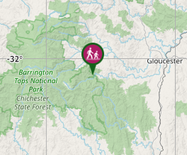
Comments