
Running Creek Falls Via Stinson Track
Lamington National Park


Menu
Running Creek Falls Campsite via Stretcher Track
Christmas creek road..
-to Westrays Grave
-to Stinson Remote Bush Camp
-to Point Lookout Bush Camp
-to Running Creek Bush Camp
-to Falls
-to car at Gap Creek Road

Getting there
Start: End of Christmas Creek Road
End: End of Gap Creek Road (or vice versa)
Maps
Which maps cover the area?
Route/Trail notes
Requires a car swap, starts at the end of Christmas Creek Road. and ending at the end of Gap Creek Road, though can do it the other way around (ps. don't park your car on the steep hill next to the lock gate at Gap Creek Road, park at the bottom of the hill for your car's sake, quite steep and narrow). Follow the track over the creek and along it till you hit the turn off to go up the ridge. Drop off packs and take a quick detour further along the creek to Westray's Grave. Return and start the (very steep) ascent up, pink tape will guide the way. Follow the track all the way up to the Stinson Campsite, the wreck is a 5-10min minute walk east from here down a fairly steep track. Could camp here, we pushed on further up to Point Lookout campsite. Will pass a junction not far along, left to the campsite and right the stretcher track continues. Point Lookout Campsite has a great view point a short distance from the campsite, would recommend over the Stinson Campsite. Had lunch here (1pm), turned back to the junction and took the other fork to continue the Stretcher track which slowly descends along a ridge.
Path is much more overgrown in this section, harder to spot pink tape, lots of tree falls- adds a lot of time to walk. Very easy to miss the turn off down to running creek (there is a tree with a double line of masking tape and a not so clear sign tacked to a tree, minimal pink tape). The descend down off the ridge is very steep and overgrown, going is very slow. Plan your time carefully, we descended as it was getting dark and took a lot of time as markers were hard to spot. Lots of wait a while and stinging nettle. Eventually got down (7pm) and camped at the first clearing that would fit the tent (we believe was the campsite, at the creek junction) was barely large enough though for our tent and our friends hammock.
Next morning, visited the falls- beware, not far from the campsite distance wise but the rock hopping and track finding adds up), allow 30-45min at least for the 1-2km one way trip). Well worth it though, the falls are astonishing and the best I have seen in Lamington. Allow plenty of time for a swim and checking out the falls.
Returned to the campsite around 11am, headed off straight back up the ridge which is much easier going in the light, still be cautious of loose rocks and branches (took around 1hr 45min). Took a short break, then continued along the stretcher track along the ridge, which will gradually descend. Still quite dense forest, though this will suddenly open up into a much less dense and dry section, were views suddenly spring up on either side. The descent suddenly gets much more steep but you can clearly see the track far ahead of you. Continue along the ridge line, which will level out and go up and down a little bit until you hit the turn off to the right off the ridge and down to the car (very, very steep! Poles really help!).
Saw lots of snakes (red bellies, pythons, copperheads, grass snakes, etc- did it in February 2021)
**FEEL FREE TO EDIT THIS, writing track notes is not my forte, wrote this as more a reference for myself**
Permits/Costs
Remote Bush Camping fees, see Gov website
Other References
How can I find more info? Any guide books?
GPS Tracks
- No GPS available for this walk yet.
 37.5
37.5 2
2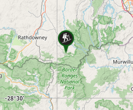
Comments
Nobody has commented on this walk yet. If you've done it then tick it off and add a comment.