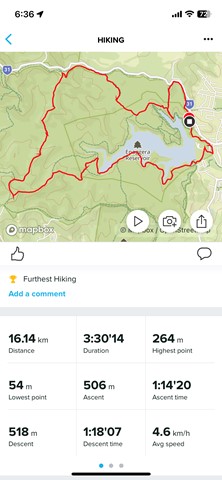
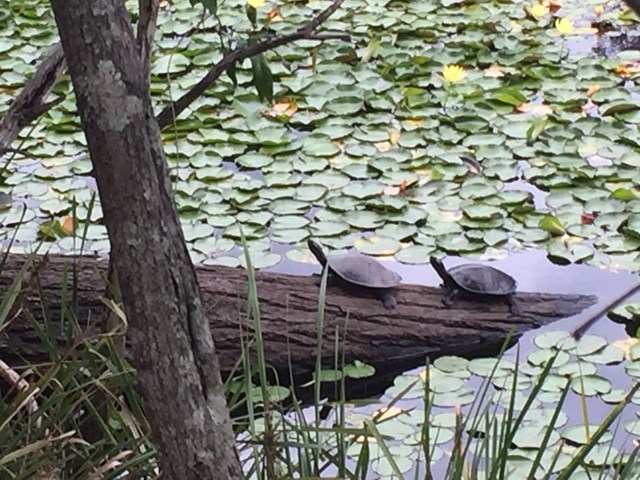
This is a beautiful walk around a large section of the bushland in which Enoggera Reservoir sits. You will walk through lots of varied vegetation, keep an eye out for goannas, lots of different birds and turtles sunning themselves on a log in the dam. A great way to spend 4 hours! I do recommend that you have a map - you can purchase the topographical map from Walkabout Creek.

Start out from the bottom carpark at Walkabout Creek, take the small track to the far right that follows Mt Nebo road. There is a very steep hill right in front of you! Follow this track for about 2 km, (turn around every now & again and you will catch glimpses of The Brisbane City skyline), The track will split - stay on the track that is to the right, still following Mt Nebo road, which is also on your right (you can't really see the road) for about another 1km. You will come to a bit of a clearing under the power lines - turn around and enjoy the view out over The Gap!

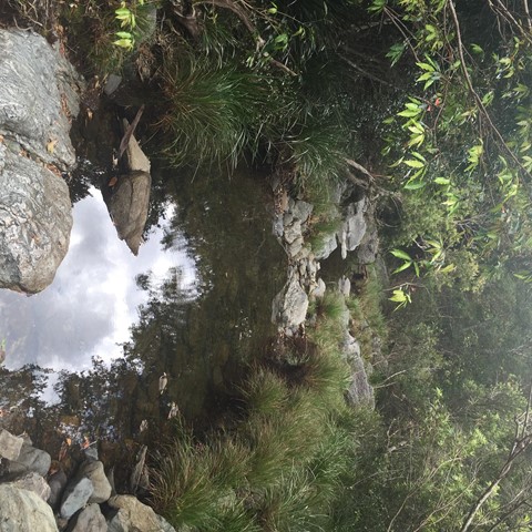
There are great views of Mt Cootha on your left and the mountain range in the distance (that I don't know the name of!). There is quite a steep descent down to a beautiful creek - take some time to enjoy a rest here as there is a VERY steep ascent ahead of you! It's probably about a 600 metre climb, which will bring you out under another power tower. Look over to the next tower - that is where you are heading! Continue along the trail for about another 1 km and you will come to a T junction, stay left for another couple hundred metres to another junction - go left again onto Fire Break 69. Don't forget to look over to your left when you reach the power tower and see how far you have come! Continue down Fire Break 69 until you reach another junction - this is McDonalds Loop. We went to the left and followed it down to the end where it hooks up to the Enoggera Reservoir loop - again we went left and followed the trail back along the reservoir to Walkabout Creek.

Getting there

Walkabout Creek is at 60 Mt Nebo Road, The Gap.  There is a bus station about 200m down the road.

Maps

D'Aguilar National Park South D'Aguilar section

Route/Trail notes

A detailed description of the walk!

Permits/Costs

None

Other References

How can I find more info? Any guide books?

Comments

Plenty of hills. Found having poles made it easier going up and down.

Mark on 14 Jul, 2023

I saw a dead python and also 2 old cars. The walk is exhausting, hills the whole way which are very steep up and down. Long walk but worth it, some nice views.

Clem on 17 May, 2023

All the trails are marked on Google maps which made it easy. Took me 2hrs as a trail run/walk. Mt nebo rd break and holmans break are extremely steep fire trails. More challenging than I expected.

Evan on 5 May, 2023

Hot day to test new backpacks! Don’t forget your hat and bring lots of water. Pretty rough for a bush road.

HellsBells on 4 Oct, 2021

Not a hard track. But certainly needs GPS map to make sure you don't confuse between many tracks that exists in that area.

Mohsen on 16 May, 2021

Solid walk. Not incredibly scenic. 500m-800m or so could only loosely be described as a track and is a hard slog through tall grass.

Hayden91 on 18 Apr, 2021

Hilly firetrails at the beginning with a couple of steep inclines, but nothing too exhausting if you've done medium tracks before. It's not the most scenic hike either, but there is the occasional nice view of the forestry / reservoir.

Not a bad hike if you're wanting to stay in the Brisbane area

JB667 on 21 Nov, 2020

Today is the second time i've done this walk in the last 4 weeks. Close to the city and a good hit out. Thoroughly enjoyable. Next time, I may try the reverse way.

Diddy on 20 Jun, 2020

Good walk close to the city. Small bit of erosion in parts from the Feb rains. Creek was up but still crossable down stream a little if you want feet dry.
Couple of breaks and did it just on 3 hours, reasonable level of fitness. As you're going up Mt Nebo section turn left at the power lines. Take a look at the northside view first, great outlook.
As you come off the 69 track onto McDonalds loop the grass is over 5ft high and covers the whole track for about 500m

Twevr on 21 Feb, 2020

Great walk can get pretty tough , take plenty of water in the hot weather

Danza1908 on 29 Nov, 2019

Very easy to follow, anyone wanting to do a solo walk that's easy to navigate it's this one (obviously with a map). Steep giant hills but plenty of rest in between. Didn't really give me that 'isolation' feeling I was after, lots of people around, big wide track the whole way so great for group walks.

patren on 22 Jun, 2019

Nice walk - have to work for the views though! Lots of steep ascents. Definitely use a map - topographic is great, but Google maps actually has most of these fire trails marked & named, so that was enough for us. The only instruction I'd add would be that at the power lines you have to turn sharp left and head down hill - towards the tower in the distance. We did this in 3.25 hours - reasonable level of fitness, but it was hard work!

KerryP on 4 Mar, 2018

Hiked this in the pouring rain - a few wet crossings. Fairly easy route finding. Agree with the difficulty rating, was quite steep in parts. A nice scenic hike.

Leith on 19 Nov, 2017

We enjoyed this walk. Pefect time of year - wouldn't want to do this in warmer weather. This track is not well marked so this guide came in really handy. We still relied on our map and phone GPS. We managed to miss the connection to the Enoggera Reservoir Loop and walked the mountain bike track back to Walkabout Creek. We thought we were on the home stretch but ended up with a lot of work to do in the last hour. It also pushed out time out to about 4 hours 40 min

Jacqui on 30 Apr, 2017

Great walk! The creek was great after the rain. Harder then we thought which was awesome. Directions were spot on :-)

Emmalea on 14 Apr, 2017

Some sections of the track needed some maintenance, either from erosion from rain washing out the trail or grass overgrowing the track at the time of our hike. The uphill sections where more numerous than expected and steeper than expected. Agree with trail ranking as hard.

Hoek's Adventures on 17 Feb, 2017

No signage but the directions on this site are spot on. Thanks!

Alicia on 26 Nov, 2016

Where

Click here to load this map.

Nearby Walks

Done this walk?

This walk has been ticked 46 times

Aussie Bushwalking can keep track of your bushwalks.

Login/signup to tick this walk off.

Tick walks to keep track of where you've been. You must Login to tick walks. Accounts are 100% free so sign up if you don't have one.