


 8
8 3
3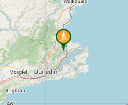
Aussie Bushwalking can keep track of your bushwalks.
Login/signup to tick this walk off.Mihiwaka, Mt Kettle & Mt Cutten via Blueskin Road
South Island NZ
Menu
A section of bush with a reservoir surrounded by three peaks.
Lookouts
Bird Watching
Scrambling or Climbing
561m
Maximum Elevation
Getting there
How do you get to the start of the walk?
From the carpark on Blueskin Road.
Maps
Which maps cover the area?
Maps of Cedar Farm Reservior & the surrounding peaks.
Route/Trail notes
A detailed description of the walk!
Follow the fire trail / 4wd trail up until the sign posted turn off to Mihiwaka. Follow the single trail to the top then return and backtrack to the Mount Kettle sign. From here go up and over Mt Kettle be careful coming down the fair side of Mt Kettle as its steep and slippery. Finally head up to Mt Cutten where just past the summit there's a turn off to a lookout with a bench & a small sculpture. Then return to the track down to the reservior and link back up with the 4wd / firetrail to the car. Alternatively from Mt Cutten you can follow a track down to Mt Cargill Rd or before venturing up Mt Cutten there are tracks following the creek down to the road.
Permits/Costs
Do you need any permits? What's the cost?
Free
Other References
How can I find more info? Any guide books?
GPS Tracks
- No GPS available for this walk yet.
Comments