
Mt Cargill, Buttars Peak, Mt Holmes & the Organ Pipes
South Island NZ


Menu
A oneway track as the walk can be done as a through walk / point to point but if doing as return then tick the walk twice and it will be ~6.6kms. From the carpark ascend to the organ pipes formation which you can scale to reach the summit of Mt Holmes then continue to Buttars Peak which is best ascended from the saddle between it and Mt Cargill. Finally summit Mt Cargill to finish your walk if you are doing it return then congratulations you have reached half way although the vast majority of the uphill will be done.

Getting there
How do you get to the start of the walk?
From Organ Pipes carpark on Mt Cargill Road.
Maps
Which maps cover the area?
Maps of Mount Cargill
Route/Trail notes
A detailed description of the walk!
A oneway track as the walk can be done as a through walk / point to point but if doing as return then tick the walk twice and it will be ~6.6kms. From the carpark ascend to the organ pipes formation which you can scale to reach the summit of Mt Holmes then continue to Buttars Peak which is best ascended from the saddle between it and Mt Cargill. Finally summit Mt Cargill to finish your walk if you are doing it return then congratulations you have reached half way although the vast majority of the uphill will be done.
Permits/Costs
Do you need any permits? What's the cost?
Free
Other References
How can I find more info? Any guide books?
GPS Tracks
- No GPS available for this walk yet.
 3.4
3.4 2
2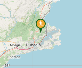
Comments
Nobody has commented on this walk yet. If you've done it then tick it off and add a comment.