
Mt. Senjo-ga-take 仙丈ケ岳 (Nagano/Yamanashi Prefecture)
Japan


Menu


Mt. Senjo-ga-take is a 3033m mountain located in the Minami Alps national park on the border between Nagano and Yamanashi. Senjo-ga-take is one of the 100 famous mountains of Japan and is one of the 20 odd peaks in Japan over 3000 metres.
You can see a wide range of wildlife including the elusive raichou, a bird which only lives at elevations of 2500m or above.
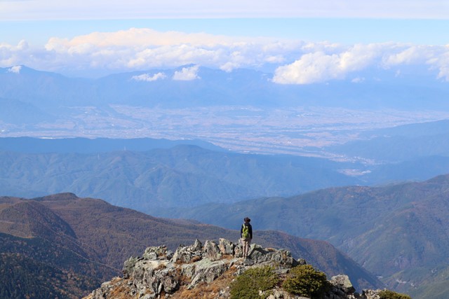
From the summit you get a 360 view of the Minami Alps and on a clear day you can see as far as Mt. Fuji.

Getting there
Begin this hike by first driving to Senryusou. This is a hotel/onsen, next to which is a large carpark and a bus terminal. The trailhead starts at Kitazawa Touge, but you are not allowed to drive on this road so you have to park at Senryusou and then take a bus up to Kitazawa Touge. Make sure you check the bus timetable before planning this hike to make sure that you don't miss the bus. Buses are very infrequent and if you miss the bus, you will miss out on the hike all together or even worse, if you miss the last bus you will effectively be stranded up on Kitazawa Touge. There is no phone signal in this area so make sure you know your bus timetable.
I think you have to pay for parking, but nobody seems to be checking so shouldn't be a biggie. Don't worry about paying for parking.
From memory the bus is about 3000 yen return. From Senryusou, the bus takes approximately fifty minutes to reach Kitazawa touge. At the Kitazawa Touge bus stop there is a toilet and a campground. If it so tickles your fancy you can camp at Kitazawa and then hike both Kai-koma and Senjo-ga-take.
Senryusou Address: 1847 Hasekurogouchi, Ina, Nagano 396-0403
Bus Timetable: http://www.inacity.jp/kankojoho/sangaku_alps/minamialps/minamialps_jikokuhyo.html
Maps
Check Yamap for free GPX files. The Trekking in Japan book also has some good maps and good descriptions of the hike.
Route/Trail notes
From the Kitazawa Touge bus stop, right in front of the toilet you will see a sign post with two arrows on it. The sign is written in both English and Japanese. One sign points towards Kai-koma-ga-take. The other points towards Senjo-ga-take. Follow the sign pointing in the direction of Senjo-ga-take. It will take you through a lush forest path for about 1.5 hours. Be warned that Senjo-ga-take is pure uphill. It is non-stop climbing. Take frequent breaks to avoid altitude sickness.
The path up to the summit is well signed and well maintained. Continue following the track up and up through the forest. As you climb higher, the forest line will start to thin and the track will become exposed. Through the tree line you should be able to make the distinct white granite peak of Kai-koma. Continue along the exposed path.
As you continue along, follow signs for Ko-senjo-ga-take. This is a minor peak on the mountain range that you should summit before going on to summit Senjo-ga-take. From the peak of Ko-senjo-ga-take you get a 360 view of the alps and Senjo-ga-take itself. Senjo-ga-take is a lushous green peak that stands out. From Ko-senjo you should also be able to see the imposing Kita-dake. Kita-dake is recognisable as it is the mountain directly next to Mt. Fuji. Kita-dake is the second tallest mountain in Japan and is impressive in its own right.
Continue past Ko-senjo-ga-take and follow the sign for Senjo-ga-take. It should take approximately an hour from Ko-senjo. Here the path narrows a bit and the incline becomes slightly steeper. Your goal should come more and more into sight. Climb up some rocks and you should reach the goal. At the summit there is enough space to eat some lunch and take the classic photo with the summit sign. The views are similar to that from Ko-senjo except that you can also see the Chuo alps and the distinctive peak of Kiso-koma-ga-take.
Do not go down the same way you came. From the summit, continue walking onwards and there should be another alternative trail leading down to a mountain hut. After passing the mountain hut, continue on the same path you came up. Follow the same path until you reach a junction for a sign pointing towards Uma no se. Follow this sign and it will take you on a loop past another mountain hut through some forest and eventually back to the starting point at Kitazawa Touge.
Once you are back at Senryusou, I recommend stopping by the onsen. Relax your muscles and bones with a nice soak. The onsen at Senryusou is 600 yen and it has a nice outdoor bath.
Permits/Costs
Bus: 3000 yen
Onsen: 600 yen
Parking: 1000 yen
Other References
Hiking and Trekking the Japan Alps (Cicerone Book)
GPS Tracks
- No GPS available for this walk yet.
 9.5
9.5 6.5
6.5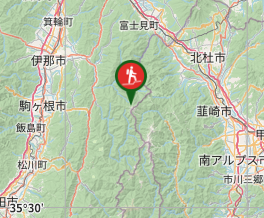
Comments
Nobody has commented on this walk yet. If you've done it then tick it off and add a comment.