
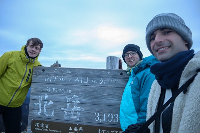
Kita-dake 北岳 (Yamanashi Prefecture)
Japan


Menu
GPS Tracks
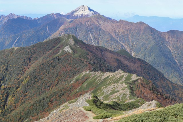
Kita-dake is one of the hundred famous mountains located in the Minami Alps National Park. Kita-dake is the second tallest mountain in Japan at 3,193 metres. It contains a wealth of rare and endangered animals and flowers.
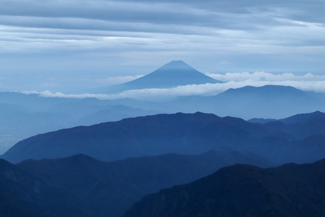
The peak has some of the best views in all of Japan, featuring a stunning sunrise where the sun rises over Mt. Fuji.
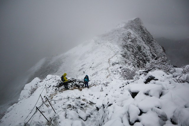
Note that this hike can only be done during the summer months, from July until mid-October. From mid-October until June, snow can be found on the mountain.

Getting there
Note that this hike is only accessible by bus. Cars are not allowed into the area that takes you to Hirokawara where you begin the hike. Here you have a few options.
You can catch a bus for Hirokawara from Kofu station if coming by train from Tokyo or somewhere else. The bus takes about two hours and costs approximately 2700 yen one way. You can use Pasmo/Suica or buy a ticket from the guy in front of the bus. Buses leave from platform 1. First bus is about 4:35am, the second about 6:55am. I wouldn’t take any of the later buses as you would not make it in time to summit Kita-dake or to the hut.
If you don’t want to take the bus from Kofu station or pay for parking around the area, you can park for free at 市営芦安駐車場 (shiei ashiyasu carpark). Buses leave here 5:15am, 5:30am, 7:50am. Tickets are cheaper if departing from here.
Maps
Check my GPX
Route/Trail notes
From the bus stop, you will see an information centre. Enter the information where there is a toilet. Feel free to use it. From the information walk to the second floor and exit. From the exit you should see a road block barricade that prevents cars from entering. Ignore this and walk right through it. On your left, there will be a long suspension bridge that takes you over a river. This is where the hike begins.
On this hike, keep a sharp eye out for the kanji 北岳. For some reason only the first few signs are written with English and provide the reading ‘Kita-dake.’ For the rest of the hike, you need to look out for the Japanese. Similarly on the return hike, you need to keep a sharp eye out for 広河原 which is the bus stop and where the information centre is.
Once you enter the forest you will probably be tricked as the path will take you into a campground. Do not enter the campground as there is no path here, instead look to your left, there will be a sign in English and Japanese pointing to Kita-dake. Follow this.
The hike wastes no time gaining elevation. It is pretty much straight up the whole way to the top. You will be gaining about 1700 metres of elevation throughout the hike. It is important that you take frequent breaks to offset altitude sickness.
Keep hiking through the forested area until the trees start thinning out. Once you exit the forest you should reach the first lodge, the Shirane Oike lodge 白根御池. Rest here. The lodge has food and drinks for sale in case you didn’t bring any. There are also toilets. There is a cool lake here too that has an interesting story if you are bothered to read the Japanese. Apparently, people in the Edo period used to come up to the lake and throw cow and horse bones into it. The lake is inhabited by a dragon-rain god. The throwing of the bones, upsets the god and makes it rain.
From the hut, continue heading upwards. There will be two paths, take the one that says 北岳, the other one, I think is a dead end. It might be an alternate route to the summit, but I personally have never taken it.
If you take the path up following the signs for Kita-dake, you will enter switch-back hell (or heaven). It is a section of almost infinite switch backs. You will have your back switched over and over again for what seems like hours. The view is pretty awesome though as this is really where the views start opening up.
Switch-back hell ends once you get to the Deer-proof(rabbit-proof) fence. Take a rest here and then continue heading upwards. Here you will enter the true alpine area somewhere about 2500 metres. You will walk across some hella sick ridgelines and get some truly amazing views of Mt. Fuji. Just keep following the obvious trails for Kita-dake. If you are lucky, you will see some Raicho, an endangered type of bird that only lives in the alps. It is very cute.
Here the terrain gets a more rocky and a bit more interesting. Nothing too hard. Just keep following signs until you reach Kitadake Kata no Koya. You can choose to stay the night here if Kita-dake is your goal. If you are going onto Aino-dake, it is better to stay at Kita-dake Sanso hut as it is further along the ridgeline.
If you are staying the night at Kitadake Kata no Koya, you can drop your pack and summit Kita-dake for sunset or rest up until morning where you can summit it for sunrise.
The climb to the peak from Kita-dake Kata no Koya is pretty straight forward. It is the steepest part of the hike, with some really narrow sections through rocks. Just keep aware of the markings and arrows drawn into the rocks and you will be fine. It is isn’t anything too difficult.
The peak is marked with a big sign that says Kita-dake in Japanese with the height of the mountain listed below. There is a small shrine where people donate money as well.
The view from the top is insane. It is a 360 no-scope MLG headshot view. You can see Mt. Fuji and the whole of the surrounding Southern Alps. You have to see it at least once in your life.
Return the same route back to Hirokawara 広河原 and keep an eye on bus timetables. Last bus is about 4pm, don’t miss it or you will be stranded.
Permits/Costs
Hut: about 8000 yen per night not including meals.
Camping is about 800~1000 yen per night.
Reservations required by calling or reserving online.
Bus is about 5000 yen return from Kofu Station.
Other References
How can I find more info? Any guide books?
 Kita-dake up (GPX)
 15
15 2
2
Comments
Nobody has commented on this walk yet. If you've done it then tick it off and add a comment.