
Mt. Hiramyoujin Loop 平明神山周回コース (Aichi Prefecture)
Japan


Menu
A challenging walk out in the sticks of Aichi with hardly any views to speak of.

Getting there
You can get to this hike by driving to the Waichi carpark (和市登山駐車場)
There is also a bus you can catch from Taguchi that will take you to the carpark; however, I cannot profess as to how frequent these buses are so if taking them, make sure to work out the timetable before embarking on the hike.
Route/Trail notes
From the carpark, follow signs for 田口, if you are lucky there will be a small sign underneath that says 大鈴山 which is the direction that you want to head towards. Note that none of the signs have any English written on them and some of the signs do not actually point you in the right direction. It can get quite confusing.
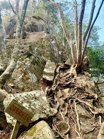
Continuing up the mountain, you should pass a small graveyard and after about forty or so minutes you will reach the peak of your first mountain 鹿島山 (Kashimayama). There are not views at the top of this peak. Instead continue right, following signs for 大鈴山 (Osuzuyama).
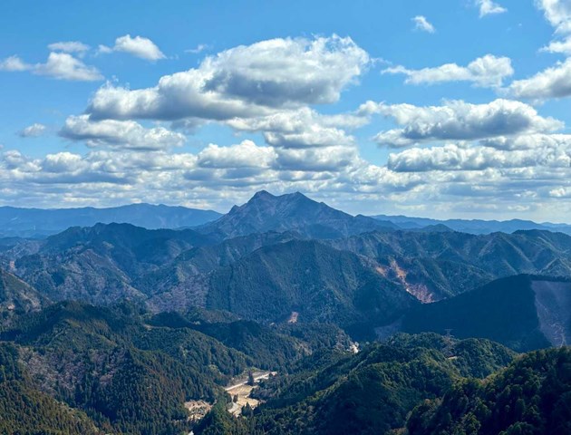
Getting to the next peak is easy enough and there actually minor views at Osuzuyama).The real challenge starts with the walk towards 平明神山(Hiramyoujinyama). Walking between each of these peaks is exhausting because as you reach the top of one peak, you descend before then ascending back up the mountain. To get to the true peak of Hiramyoujinyama, you will need to perform a short scramble to the top. This is aided by ropes. It is not exposed nor is it technical. From the peak there are also some views and a small shrine.
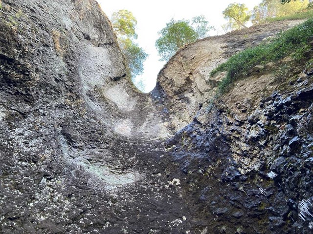
The most difficult part of this hike is the walk from Hiramyoujinyama to 岩古谷山 (Iwakoyayama). This part of the hike is very poorly signed and very easy to get lost. This is most due to the fact that signage is almost non-existent and that there are pink ribbons that mislead you. For some reason there are multiple pink ribbon paths that lead down to sections that are clearly not paths. Keep your wits about you and look for ropes as you and ropes are about to get very acquainted. There are multiple short scrambling sections aided by ropes, although this is hardly the most difficult part of this section, it is the constant up-down of the path and the extremely steep gradients. Some parts are so steep that it is difficult to even stand straight. Towards the end of this section, the path will become more exposed and supposedly there is a section where you cross an exposed knifebridge (I didn't see this part but everyone else online talks about it being very freaky). From here the hike becomes well-signed and easy to follow as you walk up multiple sets of questionable looking staircases. One set heading up the mountain is leaning to one-side and really calls into questions its structural stability.
Once at the top of 岩古谷山 you will see a marker pointing to the ruins of an old castle. There are some minor views to be enjoyed here. After relaxing for a bit continue along the path looking for signs for the 堤石トンネル. This is a well trodden descent path with a lot of concrete steps (some of which are a bit freaky). Towards the end you will pass two waterfalls and eventually be spat out on the road. From here, walk ten minutes along the road towards the Waichi carpark and you are done.
Permits/Costs
Carpark is free dog.
GPS Tracks
- No GPS available for this walk yet.
 7
7 6
6
Comments