
Grand High Tops
Warrumbungle National Park


Menu
A spectacular mountain walk through the remnants of an ancient volcanic landscape of Warrumbungle National Park in outback NSW.

Getting there:
Warrumbungle National Park is 35km west of Coonabarabran, which is about halfway between Melbourne and Brisbane on the Newell Highway. From Sydney it's about 450km (4-5 hours) via the Great Western Highway to Dubbo then the Newell Highway north. From Coonababran the John Renshaw Parkway leads straight to the park. The park visitor centre and several excellent campsites are just off the main road and close to the start of the walk. Buses can be taken along the Newell but there is no public transport between Coonabarabran and the national park.
Maps:
NSW Parks and Wildlife Service 1:40,000 tourist map
Route/Trail notes:
DAY ONE: Camp Pincham to Balor Hut, 6.8km 3 hours
From Camp Pincham car park follow the main track - Pincham Trail - to the left of a large information sign and downhill to reach a toilet block and Camp Pincham itself after 200m.
The campsite is named after Alfred Pincham, who owned the land now covered by the national park and donated it to the people of New South Wales in 1952. Bypass the camp and continue south along the valley of Spirey Creek. The walking at this stage is quite easy, almost too easy in fact; the track is about a metre and a half wide and paved with bricks, a response by the park authorities to the heavy foot traffic undertaking the popular walk to The Breadknife.
Ignore a track to the right to Ogma Gap (you will return via this track in two days) and after 1.6km turn left at a junction on to the Gould Circuit track, which is quite rough and makes for a nice change from the main path. The circuit track climbs steeply uphill towards Febar Tor - drop your packs at the base of the rocky outcrop and scramble up for great views.
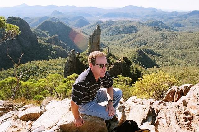
This is the first real look at the Grand High Tops on the hike, and it’s worth pausing for a break to drink in the panorama of where you will be walking over the next few days. From left to right the view encompasses the 1057m Belougery Spire, the narrow spine of The Breadknife and, looming over the top of the range to the right, the mass of Bluff Mountain. In between there are numerous smaller cliffs, peaks and outcrops.
After returning to the track and picking up your pack, continue through a saddle and up to another rocky outcrop called Macha Tor, which also has fine views, then follow the track as it descends steeply down to Pincham Trail 900m upstream from where you left it.
Turn left to continue south, following the track further up the valley alongside the (usually dry) creekbed to a junction with a side track to Hurley’s Camp. The track is marked on the map but was closed when we visited.
This point marks a change in the walking experience, as the gently sloping track up the creek valley is left behind and you begin to climb steeply to the Grand High Tops, up the appropriately named Spirey Ramp. While in this area, don’t forget to look up! The track passes below Belougery Spire, which towers above the trees like a crudely carved skyscraper.
Soon the track transforms into a flight of stairs (another concession to the impact of many feet) which continue until you arrive abruptly at the base of the Breadknife. The main route heads left, but take the rougher right-hand track for about 50m to Balor Hut.
The hut is a basic metal structure with wooden bunks and an external water tank (check with rangers before heading out to see if the tank has water in it). If you don’t wish to partake in these luxuries (which require a booking with the park office) there is space for several tents in the surrounding forest. The best thing about this campsite, though, is the views – a short scramble up rock outcrops behind the hut provides a fantastic panorama of the Breadknife and Belougery Spire.
DAY TWO: Balor Hut to Ogma Gap, 7.5km 4.5 hours
Day two begins with a return to the staircase used the night before and a thigh-straining climb up the stairs, which are soon replaced by an equally exhausting, but slightly more natural, steep dirt track, underneath the cliffs of the Breadknife. The outcrop is the remains of a volcanic feature known as a dyke, where molten rock squeezed through a vertical crack in the surrounding rock and then solidified. The Breadknife is 600m long, 100m high and only a couple of metres thick.
The track climbs above the Breadknife, passing another smaller dyke called Lughs Shield before eventually emerging on top of the range at Lughs Throne. Many of the features in the park were named by pioneer conservationist Myles Dunphy, who drew heavily on Gaelic mythology; Lugh was the Gaelic sun god.
This point is close to the centre of what was once the huge Warrumbungle volcano, and it is at the heart of the Grand High Tops – and the views are suitably outstanding. To the east and north are Belougery Spire and the Breadknife, while to the south the scenery is dominated by the 1094m pillar of Crater Bluff and its distant companion, Tonduran Spire.
From Lughs Throne the track swings west, crossing a number of rock slabs and then descending through forest to Dagda Saddle, where there is a junction with a track to the right – this is the Dagda short cut that leads under the western side of the Breadknife back to Balor Hut. Ignore this track and continue along the range for a further 1.2km to Nuada Gap and the turnoff to Bluff Mountain. There are plenty of spots for tents between the trees if you want to spend the night here (there was also a hut until it was removed in 1980), or to leave your pack for the 2.6km side trip to the top of the impressive lava dome of Bluff Mountain.
The side track winds uphill to the west through eucalypt forest and extensive groves of grass trees, slowly contouring back and forth up the eastern slope of the peak, before swinging north for the final climb to the summit plateau. At this point the forest opens up into heathland, providing grandstand views of the entire park. Be careful on the final stage to the summit cairn as the surrounding cliffs are more than 200m high.
After taking a well-deserved break on the mountain summit (which makes a great lunch spot) return to your packs and head south along the crest of the range. This area is known as Dows High Tops and is lower and less open than the Grand High Tops, but there are still a number of places where you can obtain good views, especially of the cliffs of Bluff Mountain to the left and ahead to the peak of Mt Exmouth, which at 1206m is the highest peak in the park.
The track undulates gently up and down for about half an hour then descends steeply to the campsite at Ogma Saddle.
DAY THREE: Ogma Gap to Pincham car park, 10.6km 4 hours
The final day of the hike features the lengthy but rewarding climb to the top of Mt Exmouth followed by a gentle downhill hike back to the car park. The bonus is that because the Mt Exmouth trip is a return journey, packs can be left at the campsite – but remember to take some food and water, and your camera.
The track from the campsite is signposted and heads west along the Western High Tops, passing through the delightful Grassy Glades – at their best when spring wildflowers are in bloom – before climbing to a junction. Take the side-trip to the left to see the curious geological formations the Cathedral and Arch before returning to the main track; the diversion takes about 45 minutes.
The track descends to Danu Gap (Danu is the chief goddess of the Gaelic Panthon) and cross the Burbie Fire Trail to begin the climb to Mt Exmouth. Continue west, heading steeply uphill to pass under the summit cliffs, then swing to the east to pass through an impressive stand of grass trees on the way to the summit, marked by a trig point.
The vast open summit is extremely exposed but on a fine day the views are outstanding. Mt Exmouth is one of the few remaining remnants of the outer slopes of the volcano; to the west are vast plains while to the east – “inside” the volcano – are all the peaks, outcrops and landmarks that make up Warrumbungle National Park.
From the summit retrace your steps back to Ogma Camp, pick up your packs and take the track to the left, heading north and downhill along the valley of West Spirey Creek. After 3km cross a footbridge to link up with Pincham Trail, the path walked on the first day. To the right is the Grand High Tops, to the left is the car park. The final 1.1km can be enlivened by searching the tree tops for koalas, which are known to inhabit the creek valley.
Permits/Costs:
A permit is required for overnight trips and you also need to book to stay at Balor Hut. Costs for both are minimal.
Other References/Commets:
An excellent walks booklet is available at the national park visitor centre.
For photos of this hike and other great Australian walks visit wildsight.com.au and look up Wildsight on Facebook.
GPS Tracks
- No GPS available for this walk yet.
 24.9
24.9 3
3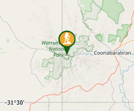
Comments