
Spit Bridge to Manly
Greater Sydney


Menu

A classic Sydney bushwalk around the northern beaches. Nice views, many swimming bays and beaches - but does get pretty busy.

Getting there
Drive to the carpark at the intersection of Battle Boulevard and Manly Rd (parking fees payable) or public transport is available.
You can also start from the bus stop on the north end of The Spit Bridge.
Route/Trail notes
Head from the carpark towards the water then down the stairs following the signs. The track provides plenty of guidance and also includes informative signs.
Check http://www.manlyaustralia.com.au/information/what_to_do/walks/walkway.asp for a map of the walk.
Other References
http://www.environment.nsw.gov.au/nationalparks/parkwalking.aspx?id=n0039
http://www.manlyaustralia.com.au/information/what_to_do/walks/walkway.asp
http://members.ozemail.com.au/~russo/oceanbeach/spit.html
https://hikingtheworld.blog/2017/04/14/the-spit-to-manly-sydney/
GPS Tracks
- No GPS available for this walk yet.
 9.1
9.1 3.75
3.75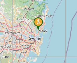
Comments