
Menu
Popular Walks
-
The Beeches
(2 ticks) -
Keppel Lookout Trail
(2 ticks) -
Cumberland Walk
(2 ticks) -
Phantom Falls
(2 ticks) -
Keppel Falls
(1 tick)
Parent Regions
Summary
Yarra Ranges National Park is in Victoria's Central Highlands, 107km from Melbourne. Established in 1995, the park's 76000 hectares protects the majestic Mountain Ash tree and a variety of fauna including the endangered Leadbeater's Possum as well as kangaroos, wallabies, wombats, platypus and 120 species of native birds. The park also hosts sources of Melbourne's water supply and the Yarra, O'Shaunessy and Taggerty rivers flow through the park.
Popular Walks
-
The Beeches
(2 ticks) -
Keppel Lookout Trail
(2 ticks) -
Cumberland Walk
(2 ticks) -
Phantom Falls
(2 ticks) -
Keppel Falls
(1 tick)
Parent Regions
History
In 1860 the area was settled and used as a source of timber. Later the opportunity as a water source was recognised and the Maroondah and Upper Yarra dams were built in 1927 and 1957 respectively.
Features
Walks in the park provide access to a variety of waterfalls, majestic trees and outstanding views. Cross-country skiing and toboggoning are available at Lake Mountain.
Access
Since there are a variety of access points please see the individual walks for details.
Contact details
http://parkweb.vic.gov.au/explore/parks/yarra-ranges-national-park
Walks in Yarra Ranges National Park

 4
km
return
4
km
return
 2
hrs
2
hrs
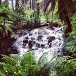
Beeches Rainforest Walk
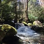
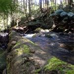
Magnificent trees, cascades and a meeting of rivers - the Beeches Rainforest Walk is a beautiful walk on Lady Talbot Drive. It includes the Taggerty Cascades and groves of Myrtle Beech trees (Nothofagus cunninghamii) including many trees over 300 years old.
4
km
return
2
hrs
Cumberland Walk
This easy walk through beautiful rainforest includes waterfalls, views and spectacular trees including The Big Tree - the tallest known living tree in Victoria. The walk also visits Cora Lynn Falls, Cumberland Falls, the Sitka Spruce planted by a forest ranger over 60 years ago and Sovereign View, a lookout over the Armstrong Creek Valley towards Warburton.
 2
km
return
45
mins
2
km
return
45
mins
Keppel Falls
Another short walk on the Lady Talbot Drive section of Yarra Ranges. See Keppel Falls on the Taggerty River and stop off up the road at Keppel Falls Lookout for a view of the Taggerty River Valley including the falls.
11
km
return
4
hrs
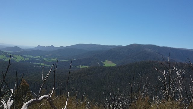
Keppel Lookout Trail
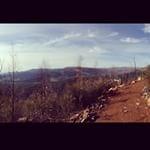
The most challenging walk in the area, Keppel Lookout Trail climbs up through Mountain Ash and Stringybark forest to visit four of Marysville’s best lookouts.
There are spectacular views across Marysville, Cathedral Range State Park and Steavenson Falls. The trail is fairly uneven and steep in places, and walkers need to be self sufficient with food and water and wear sturdy footwear.
 3.5
km
return
2
hrs
3.5
km
return
2
hrs
Mount Donna Buang (Summit)
Easy peaceful walk from the lower carpark area up to the summit of Mt Donna Buang. Relatively easy ascent in the dryer months, however can become moderately difficult in the winter months due to snow and rain making sections of the climb slippery.
(PBA my climbing data has been deleted off of my watch/phone all numbers are estimations)
1.6
km
return
45
mins
Phantom Falls
A short steep walk through a moist fern gully leads to a wonderful view of these falls. Spring is the best time as the melting snow brings the falls to life.
4
km
return
2
hrs
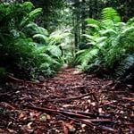
The Beeches
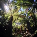
Immerse yourself in the best rainforest trail the national park has to offer.
This enjoyable circuit walk skirts through Mountain Ash regrowth before entering a delightful temperate rainforest of Myrtle Beech, Southern Sassafras, Blackwood, tall tree ferns and thick green mosses.
The trail passes Taggerty Cascades, which provide a noisy contrast to the quiet Whitehouse Creek.
A number of timber bridges and floating boardwalks are crossed along the way.
Lyrebirds are common in the area.