
The Beeches
Yarra Ranges National Park


Menu


Immerse yourself in the best rainforest trail the national park has to offer.
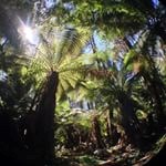
This enjoyable circuit walk skirts through Mountain Ash regrowth before entering a delightful temperate rainforest of Myrtle Beech, Southern Sassafras, Blackwood, tall tree ferns and thick green mosses.
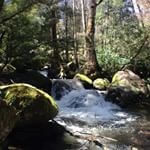
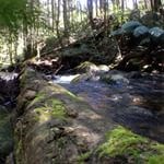
The trail passes Taggerty Cascades, which provide a noisy contrast to the quiet Whitehouse Creek.
A number of timber bridges and floating boardwalks are crossed along the way.
Lyrebirds are common in the area.

Getting there
Lady Talbot Drive provides the most spectacular rainforest walks in Marysville. Lady Talbot Drive starts on Woods Point Rd and follows the Taggerty River valley up under the western flanks of Lake Mountain to the top of Mt Margaret Gap.
From here you can complete the 46km Lady Talbot Forest Drive by continuing down Mt Margaret Rd, through state forest to the Buxton – Marysville Rd and back to Marysville.
There are a number of forest walks, lookouts and picnic spots along the way.
Since the 2009 Black Saturday bushfires, Lady Talbot Drive has changed considerably and there are now extensive views up and down the rushing Taggerty River and the many surrounding mountains.
The major places of interest are Phantom Falls, Keppel Falls, Taggerty Cascades and The Beeches. Lady Talbot Drive is suitable for two wheel drive vehicles, but in dry weather only.
The road beyond The Beeches is best suited to four wheel drive vehicles.
Lady Talbot Dve, The Beeches car park
Maps
Which maps cover the area?
Route/Trail notes
A detailed description of the walk!
Permits/Costs
Do you need any permits? What's the cost?
Other References
How can I find more info? Any guide books?
GPS Tracks
- No GPS available for this walk yet.
 4
4 2
2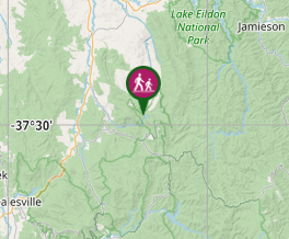
Comments