


Menu
Explore the legendary Tintagel Castle.

Getting there
How do you get to the start of the walk?
From The Castle Carpark / the beginning of Castle Road.
Maps
Which maps cover the area?
Maps of Tintagel
Route/Trail notes
A detailed description of the walk!
Follow castle road down to the bridge and across onto the island and walk the loop exploring the castle before heading down the stairs and under the bridge back onto the mainland. Detour down to the beach and Merlins Cave (you can access this area without paying for the castle). Once finished there is a cafe at the bottom of Castle Road as well as an information centre with a little museum display. Once finished head back up castle road to your car.
Permits/Costs
Do you need any permits? What's the cost?
Cost of parking plus castle entrance fees.
Other References
How can I find more info? Any guide books?
N/a
GPS Tracks
- No GPS available for this walk yet.

 3.5km return
 3hrs
Where
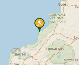 Map data © OpenStreetMap contributors. Terrain: © Geoscience Australia.
Comments
Nobody has commented on this walk yet. If you've done it then tick it off and add a comment.