


Menu
Follow the Southern Rim of England's largest gorge.
Lookouts
254m
Maximum Elevation
136m
Total Climb

Getting there
How do you get to the start of the walk?
Start from the Black Rock Carpark in Cheddar Gorge
Maps
Which maps cover the area?
Maps of Cheddar Gorge
Route/Trail notes
A detailed description of the walk!
Start steeply uphill to the rim of the gorge. Follow the cliff edge to Castle Rock / The Pinnacles which has some of the loftiest views of the gorge. On your way back down head over the top of the knoll looping around to rejoin your path just before the main descent to the car.
Permits/Costs
Do you need any permits? What's the cost?
Free
Other References
How can I find more info? Any guide books?
N/a
GPS Tracks
- No GPS available for this walk yet.

Medium
 2.65km return
 1hr
Lookouts
Where
Click here to load this map.
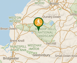 Map data © OpenStreetMap contributors. Terrain: © Geoscience Australia.
Comments
Nobody has commented on this walk yet. If you've done it then tick it off and add a comment.