Mount Robert

North Queensland

Standing about 1000m high, Mt Robert, in the Boyne Valley is the highest mountain between the Gold Coast and Townsville. The Boyne Valley is a rural locality in Gladstone Region, Queensland, Australia. Mt Robert is situated on private property therefore can only be climbed when the family allows access usually once a year around July.

Lookouts
BBQ
Scrambling or Climbing
Camping Permitted
Rainforest
1000m
Maximum Elevation

Getting there:

Harmony Farm is on Prizemans Road, Ubobo, Queensland Australia 4680

From Gladstone:

Head north-east on Crow Street towards Hanson Road/State Route 58

140m

Turn left onto Hanson Road/State Route 58.

2.4km

At the roundabout, take the 2nd exit and stay on Hanson Road/State Route 58.

600m

At the roundabout, take the 1st exit onto Red Rover Road.

3.4km

Continue onto Don Young Drive.

2.2km

Turn right onto Dawson Highway/State Route 60

18.5km

Turn left onto Gladstone Monto Road/Tableland Road/State Route 69.

Continue to follow Gladstone Monto Road/State Route 69.

56.6km

Sharp right onto Bowman Road.

100m

Turn right onto Rushbrook Road.

3.2km

Turn left onto Prizemans Road.

Partial restricted-usage road.

5km

Harmony Farm, Prizemans Rd, Boyne Valley QLD 4680

Maps:

https://www.google.com/search?q=Gladstone+to+harmony+farm+ubobo&rlz=1C1GCEA_enAU928AU928&oq=Gladstone+to+harmony+farm+ubobo&aqs=chrome..69i57j69i60.6238j0j15&sourceid=chrome&ie=UTF-8#

Route/Trail notes:

A detailed description of the walk!

Permits/Costs:

Nil cost however Harmony Farm is private property therefore you can only climb this mountain when the family opens it up at certain times of the year.

Other References/Comments:

How can I find more info? Any guide books?

GPS Tracks

  • No GPS available for this walk yet.

Comments

Mt Robert is located in the beautiful Boyne Valley west of Gladstone, Bundaberg areas. It's on private property called Harmony Farm and the family usually opens their property up once a year around July for the event of climbing.
In July 2015 I joined one of these events and attended the farm to climb this mountain for my 47th birthday with the only victim I could find. We had absolutely no idea what was in store.
We commenced our climb very early and was guided for the first hour by the owner around a mountain in heavy, long grass until we were advised the start of the climb had been reached. At this point the owner left us with a smile and a wave and we were off.
To reach the summit you traverse upward along a riverbed. There is no track but if you stick to the obvious riverbed you will be fine.
It took the 5 of us front runners 3 hrs to get to the summit which is beautiful. There is a book that lives in a pipe drilled into the rock for you to put your name and the time it took to reach the summit.
We then headed back. It was much harder to stay on track heading down and we got lost several times. It got very frustrating. In short we took just over 3hrs to get back.
As you will see, there is very little to absolutely no information on this mountain. If there was you would fully understand that this is no beginners hill.
A very good level of rock scrambling skills is required and for a 6hr turnaround a good level of fitness. There are no easy spots. There was very little phone reception which was frightening as we could not see anywhere a rescue chopper could hover if we were injured and had to be extracted. For a team to reach you and carry you out would be a major effort and extremely painful for the victim. We actually had a stern talk to the owner on our return about the safety hazards and how future climbs could be organised in a much safer way but felt we were not heard.

Tess on 26 Jul, 2015

Where

Click here to load this map.

Done this walk?

This walk has been ticked 1 times

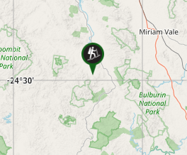
Aussie Bushwalking can keep track of your bushwalks.

Login/signup to tick this walk off.

Tick walks to keep track of where you've been. You must Login to tick walks. Accounts are 100% free so sign up if you don't have one.