
South Bald Rock RBC via the Stone Cottage
Girraween National Park


Menu
GPS Tracks
Approximately 8km walk from the stone gate, and then via the old stone cottage to South Bald Rock remote bush camp (yes, there's a "camp"). This walk takes you East along some lovely grassy flat land and around a few rocky outcrops before travelling clockwise around the Northern edge of West Bald Rock, then South, counter-clockwise around Middle Bald Rock, before finally descending into a semi-swampy valley on the Western edge of South Bald Rock. Around the rocky areas there's some ups and downs but easily achievable for someone of moderate fitness and ability. There's a lone "no fires" sign installed indicating the general camp area. Pick your camp site well, as with just a reasonable shower of rain the water only goes downhill. Wouldn't recommend this location during heavy storms or heavy rains, as rising creeks could be hard to predict for beginners.

Getting there
From Wallangarra, make your way to the Mt Norman Road Southern entrance and follow that road until you see the large stone gateway. This is the start of the track, but be aware there is not established parking, and definitely nowhere for non-offroad vehicles
Maps
The available Girraween National Park maps purchased online do not cover the entirety of this walk. The Easternmost section (the camp area) is mostly not included.
Route/Trail notes
You can follow the existing (but inaccessible) 4WD tracks the entire way to the camp location. After you walk up from the gate to the old cottage, keep going downhill and you'll emerge into a lovely wandering clearing for a couple of KMs, after this the track begins to twist around rocky outcrops where you will be up and down in short bursts. While overall the track is mostly up on the way in, it's well broken up into reasonable portions of both. After you pass around West Bald rock on your right hand side, the track around the south of Middle Bald rock has a short section of exposed rock which could be slippery if not taken with caution. Once you hit the downhill after Middle Bald rock just follow the track and eventually you see an "intersection" when you'll need to head North, putting the creek on your left and the rock on your right. A couple of hundred meters down the track you'll find the "no fires" sign in the general vicinity of the South Bald Rock remote bush camp. Be aware there are some traces of old barbed wire laying in amongst the scrub.
Permits/Costs
Camping permit per night is $8 (2023).
Other References
There's probably other info available online and in publications somewhere. But I didn't find any.
 South Bald Rock RBC via the Stone Cottage (GPX)
 8
8 2
2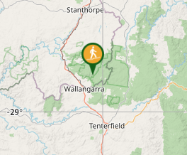
Comments