
Yarigatake 槍ヶ岳 (Gifu/Nagano Prefectures)
Japan


Menu
GPS Tracks


Yarigatake is one of the 100 famous mountains in Japan. It is located in the Northern Alps and is one of the most instantly recognisable peaks in Japan. It is the 5th tallest mountain in Japan, and is just awesome. A two day with a thrilling scramble. Being 3000m above sea level, things just hit different.

Getting there
There are multiple trailheads and places you can start Yarigatake from. Here I will list the most popular approach to the mountain.
Start at Kamikochi. It is illegal to drive your own car up to Kamikochi, thus you have to park at Sawando Bus terminal (parking is 700 yen per day) and then take the bus up to Kamikochi (2400 yen return).
It is also possible to catch a bus direct from Tokyo, Takayama or Matsumoto to Kamikochi
Check this website for more details. https://www.alpico.co.jp/en/timetable/kamikochi/
As this is a long hike, I recommend getting to Kamikochi as early as possible.
Maps
Yamap
Route/Trail notes
Day 1
NOTE: Hiking season is from late July until early November. Do not attempt to hike outside of these months unless you are prepared to hike in the snow.
From Kamikochi walk from the bus terminal to Kappa bridge. Do not cross the bridge, continue on walking. You will see a campground, continue to walk beyond the campground. Think of campgrounds and huts as rest stops and markers as they often have toilets, food, cafes and water.
The first 15km of the hike is quite flat and not very interesting. You follow a gravel road most of the way. From Konashidaira campground (the first campground), continue along, following signs for Myojin-ike (Myojin lake). This will be your next pit stop. From there continue straight, without going to the lake to Tokusawa. Here there is a hut that sells ice cream. From Tokusakawa, head in the direction of Yokoo. Here is where the hike really starts to get interesting.
Yokoo is the last big hut on the journey. It is also a good place to start hikes. At Yokoo there will be a crossroad, one with a bridge heading towards Karasawa and one going straight into the forest, heading for Yarigatake. Follow the signs for Yarigatake. Here you will meander off into a nice hiking path and follow the contours of the valley until you reach Yarisawa hut. Yarisawa hut is located at the base of the mountain range, after that, it is a long climb up to the summit of Yari.
There is only one path up the mountain, which is relatively easy to follow. Due to the gradient of the hike, it is a lot of switchbacks. Parts of the river is pretty cool. Snow is still visible until quite late into the season (not on the trails). If you are lucky you will also see Raicho, a rare type of bird that only lives in the Japanese alps. Monkeys are also quite common.
As you climb up and up, Yari should come into view. The peak juts out and looks like a spearhead, it is impossible to miss. Towards the top, you will see two huts. One at a lower elevation (Sessho hut) and one just below the peak, Yarigatake Sanso. I recommend staying at Yarigatake Sanso ($100 per night) as it is the perfect base for then climbing to the peak of Yari the next morning. Although possible to smash out the summit to Yari when you arrive, I recommend holding off until the next day, as the sunrise is amazing from the peak.
Day 2:
Wake up at 4am and get ready for the hike to the peak of Yari. I recommend dropping your pack at the hut and only taking essentials. The climb to the top is 100% scramble. Any excess weight is unwelcome. From the hut there is a clear path heading towards Yari. follow this and quite quickly the scramble beings. There are paths for both upwards ascend and downwards descent. Keep an eye out for these markers which are painted into the stone. Stones with circles on them, tell you the way to go, circles marked with an x, mean don't go there.
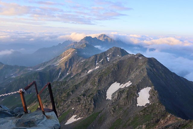
The climb up Yari is not technical, but it is scary for those who do not have a head for heights. At all stops there are ladders and chains to help you with the scramble. A helmet is advised so you don't die when hit by a falling rock. You need to keep your wits about you and move carefully. It can get quite busy which leads to bottlenecks going up the mountain. There is only about space for 20 or so people to be at the peak at once. The scariest section of the climb are the ladders. They are verticle, and when descending, can be quite intimidating as getting your foothold is not always easy. But once you get to the summit, the views are unbelievable. You get an amazing view out to the Daikiretto and the Hotaka mountain range, the valley you climbed up and out the alps and beyond. In the morning at sunrise, the clouds are still in and you see the tops of mountains floating above the clouds. It is just stunning.
When descending the mountain, you have a few options. You can go back the way you came which is what I did OR
You can continue on a different path and finish at Shin-Hotaka ropeway. If parked at Sawando carpark, you can take a bus back to Sawando from Shin-Hotaka.
If you are brave and want to keep on hiking the alps as Yarigatake is a great access point to the rest of the alps. Keep on climbing. Follow the ridge line across the Dai-kiretto onto Oku-Hotaka-dake, the third tallest mountain in Japan. Just be warned that this path is very dangerous. Quite a few people die each year. Even though the path has ropes and chains to aid you across the razorback ridgeline, it is only to be attempted by those who have experience and self-confidence to travese the ridge. The ridge has a massive drop in elevation before coming back up again to Hotaka. Please do not take it lightly.
Once back at Sawando carpark, I recommend hitting up the Sawando onsen and heal your sore muscles and bones. It will perk you right up! Nice outdoor views and lots of other hikers to have chats to.
Permits/Costs
Car park - 700 yen per day
Bus to Kamikochi - 2400 yen return
Hut - 10,000 yen per night
Onsen - 750 yen per night.
Other References
Hiking in Japan book
 yari (GPX)
 45
45 2
2
Comments
Nobody has commented on this walk yet. If you've done it then tick it off and add a comment.