


 9.4
9.4 5
5Aussie Bushwalking can keep track of your bushwalks.
Login/signup to tick this walk off.Mount Adatarayama 安達太良山 (Fukushima Prefecture)
Japan
Menu
Mount Adatarayama is one of Japan's 100 famous moutains located in Bandai-Asahi National Park in Fukushima Prefecture. It is an active volcano that has some of the most stunning views in north Japan.
Public Transport
Alpine
1728m
Maximum Elevation
Getting there
You can get to this hike either by driving or taking public transport. Just be warned if taking the bus, there are only 3 buses per day that take you to the trailhead and back.
Plug Okudake no Yu onsen into google maps and drive there, free parking next to the onsen where the track starts.
If catching the bus, it leaves from Nihonmatsu station at approximately 8am. Try to time it to make it back for the 4pm bus.
Maps
Google my man
Route/Trail notes
There are two ways of beginning the hike. You can cheat and take the ropeway which will take you something like 2 hours to return to complete the whole hike or you can walk from the onsen to the peak. This way is much more rewarding (and cheaper). Sinage on the mountain is really bad. For some reason the only sign in English is near the peak. For the way up, you have to be really perceptive and aware of the signs that point towards 安達太良山
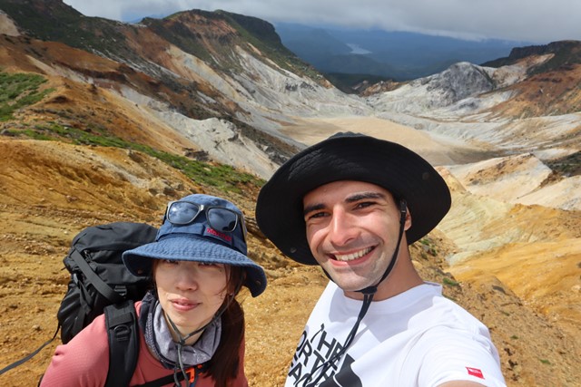
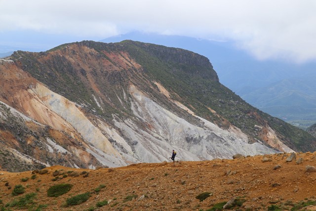
The first portion of the hike is covered in plants and you walk through some pretty ugly sections that cross over with the ropeway. As you get higher, the plants thin out and the hike is more exposed. Here is where you will start to some beautiful volcanic scenery. Continue folloiwng signs for the summit. Gettin the peak involves climbing up a small ladder and looping around. From the peak you will get an amazing view.
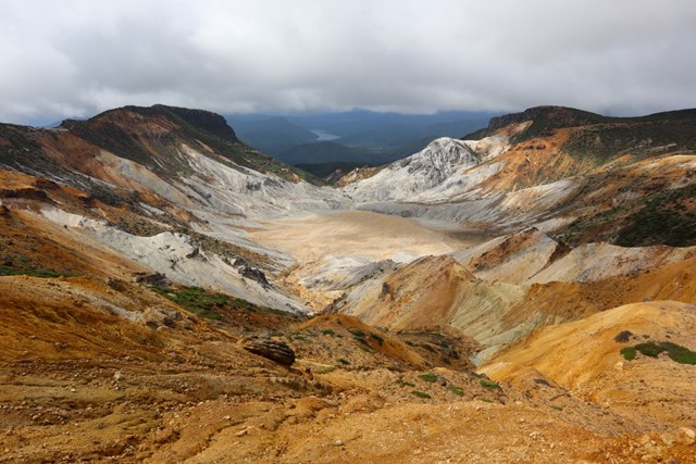
From the peak, I recommend walking over to 鉄山. This will add another fifteen or so minutes to your hike, but is really worth it. Find the trail by climbing back down from the peak to the trial and then make a right turn towards the epic white volcanic rock you can see in the distance. On the way to 鉄山 there is a lookout that gives you a view into the crater of Adatarayama which is nothing short of breathtaking.
On the way down, follow signs for 黒鉄小屋. It is engraved into some rocks along with the way. This will take you down the mountain, but a different way. Continue following this path. Once you reach a junction, take either the left or the right path. Both paths lead will take you back to the starting point and there isn't much difference.
Once you have reached the base of the mountain, it is almost an obligation to go into the onsen. It has a great outdoor bath that can't be missed.
Permits/Costs
Onsen and ropeway (optional costs).
GPS Tracks
- No GPS available for this walk yet.
Comments
Nobody has commented on this walk yet. If you've done it then tick it off and add a comment.