


 1
1 30
30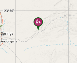
Aussie Bushwalking can keep track of your bushwalks.
Login/signup to tick this walk off.Corroboree Rock Walk (East Macdonell Ranges)
Northern Territory
Menu

Corroboree Rock is a dark grey column of dolomite an hour's drive east of Alice Springs.
It’s one of many sites in the MacDonnell Ranges that’s of great importance to the Eastern Arrernte people.
Take a short walk around the base of the rock to survey the area and have a closer look at the ancient sedimentary, fine-grained rock. At the base you can see dark grey and light grey streaky blobs of dolostone rock. A ring of low ground surrounding it makes it look like an obelisk.
The real significance of the rocky outcrop to the Eastern Arrernte people is not well known. Corroboree Rock was probably not a corroboree site due to the lack of water in the area, but was probably used as an important storage site for ceremonial objects.
The rock itself is an outcrop of dolomite from the Bitter Springs Formation originally laid down in salty lakes 800 million years ago.
Corroboree Rock Conservation Reserve is an easy stopover on your way to other East MacDonnell landmarks such as Trephina Gorge and Arltunga. The reserve is easily reached along the sealed road by two-wheel drive vehicles.
Lookouts
Toilets
Arid or Desert
Getting there
How do you get to the start of the walk?
Ross Highway, 43 kilometres east of Alice Springs, Alice Springs, Northern Territory, 0870, Australia
Maps
Which maps cover the area?
Route/Trail notes
A detailed description of the walk!
Permits/Costs
Do you need any permits? What's the cost? Free
Other References
How can I find more info? Any guide books?
GPS Tracks
- No GPS available for this walk yet.
Comments
Nobody has commented on this walk yet. If you've done it then tick it off and add a comment.