


Aussie Bushwalking can keep track of your bushwalks.
Login/signup to tick this walk off.Menu
A walk through the Water Meadows on the banks of the Avon & Nadder Rivers to the Salisbury Cathedral which has the tallest church spire in England (123m).
Heritage Sites
Picnic Facilities
Swamp or Wetland
55m
Maximum Elevation
61m
Total Climb
Getting there
How do you get to the start of the walk?
You can start at many places around the walk although from the Town Path near The Old Mill on the River Nadder is a nice place to start and finish.
Maps
Which maps cover the area?
Maps of Salisbury
Route/Trail notes
A detailed description of the walk!
Start on the Town Path near the Old Mill on the River Nadder. Cross the river and make your way through the water meadows before crossing the other branch of the river into Queen Elizabeth Gardens. From there continue downstream through the park to the junction with the River Avon and then upstream to a bridge. Cross the bridge into the middle of town and take a right onto High Street. Continue South down the street into the parklands and past the Cathedral. Continuing onto the broad walk past the bug cathedral. Turn left onto De Vaux Place then right onto St Nicholas Road. Here you will cross the River Avon then turn right onto Harnham Road. Then turn right through the parklands back to the start.
Permits/Costs
Do you need any permits? What's the cost?
Free
Other References
How can I find more info? Any guide books?
N/a
GPS Tracks
- No GPS available for this walk yet.

Easy
 3.75km return
 2hrs
Heritage Sites
Picnic Facilities
Swamp or Wetland
Where
Click here to load this map.
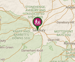 Map data © OpenStreetMap contributors. Terrain: © Geoscience Australia.
Comments
Nobody has commented on this walk yet. If you've done it then tick it off and add a comment.