
Mt Tyndall Summit + Cave
West Coast Tasmania


Menu
Short walk through swampy teatree, climbing up to exposed rocky goat path to summit and surrounds. There is good water halfway up and at the plateau the track branches off. Take the left path to the summit, the last 500m is unmarked and offers some rock scrambling and pushing through low bushes. The right leads to hilltop lakes, a cave for overnight camping and a great view of the ampetheatre lake Huntley

Getting there
Driving along Arthur road after lake plimsoll there'll be a dirt road turn off with old tyres stacked near the road, park just off the road and follow the track over the creek, turn left at 't' intersection and follow to find the trailhead and logbook
Maps
Which maps cover the area?
Route/Trail notes
A detailed description of the walk!
Permits/Costs
Do you need any permits? What's the cost?
Other References
How can I find more info? Any guide books?
GPS Tracks
- No GPS available for this walk yet.
 3
3 2
2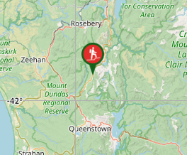
Comments
Nobody has commented on this walk yet. If you've done it then tick it off and add a comment.