
Pine Gorge and the ‘Shower Room’ (Lower Mcgrory Falls)
Bunya Mountains


Menu
Please note that this is not a formed walking trail, is located in a reasonably remote location and that a degree of navigation skills are advised. The walk is best started from the end of the old log haulage road off of Saddle Tree Creek Road (-26.8636213, 151.6332056). From the small dirt patch at the end of the log road near Saddle Tree Creek (enough for a couple of cars to park), follow the main eroded creek bed. There is lantana and fallen trees in this lower section of creek, so a good degree of care should be taken. Using the usually dry creek bed to navigate, you will come to a fork at approximately -26.8663406, 151.6258194. Take the branch to the right, following the creek bed. The vegetation will gradually change from dry eucalyptus scrub and ‘balds’ to wet scrub as you ascend along the creek. If correctly followed, the Saddle Tree Creek bed should gradually begin to contain small permanent pools (even in drier weather). In normal conditions, at this stage the creek will begin to contain running surface water. Bunya Pines with the centuries old characteristic cut out ‘foot holds’ from Aboriginal visitors can be spotted as the only sign of human disturbance. Towards the end there are some small waterfalls that will need to be carefully scaled. The walk will end in a narrow gorge at approximately -26.8752181, 151.6039648, with a fairly impressive waterfall (except during very dry times) giving the illusion of a shower cubicle.

Getting there
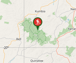
The best place to start is from a small dirt parking spot at -26.8636213, 151.6332056, at the end of an old log haulage track. This can be accessed from the Maidenwell-Bunya Mountains Road, by turning onto the gravel Saddle Tree Creek Road. Drive along this gravel road until you see a track veering off to the left (marked with national parks sign). If you reach the bitumen, you have gone too far. Follow the track until you get to the dirt parking area near the eroded creek bed.
Maps
Download a copy of the QTOPO map for the area.
Route/Trail notes
A detailed description of the walk!
Permits/Costs
Do you need any permits? What's the cost?
Other References
How can I find more info? Any guide books?
GPS Tracks
- No GPS available for this walk yet.
 ??
?? ??
??
Comments
Nobody has commented on this walk yet. If you've done it then tick it off and add a comment.