
The Quiraing
United Kingdom


Menu
A beautiful and sometime challenging hike with some of the best views of Scotland.

Getting there
From Uig, continue north up the A87 until you get to the A855.
The Quiraing is situated in the north of Skye in the area known as ‘Trotternish’. The start of the walk is accessed from either of the villages of Staffin or Uig, which are joined by a single track road.
Maps
Google: JPH6+C4 Portree, United Kingdom
Route/Trail notes
Note: This walk is not suitable in all conditions. Parts of the hike are narrow and walking in windy or rainy weather could be dangerous.
Stage 1
Follow the path that leads north from the carpark, the path is rough under foot with steep grassy slopes on your right hand side.
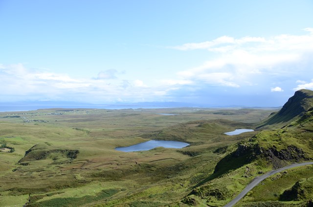
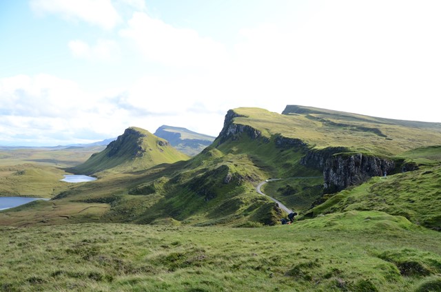
As you look ahead you will see high cliffs & to the right a rock structure which is known as the Prison. From particular directions is looks like the fortress walls of an ancient Prison.
After about 10mins you will reach one of the more challenging parts that involves scrambling over a rock gorge to cross a small stream. Check the Photo Slideshow – (It is possible to navigate around this by leaving the path and heading lower down the grassy slope)
After a careful crossing the path leads on towards the Prison and then passes between the Prison and the high cliffs. By the prison you must ascend up a bank of scree (lose gravel).
With the Prison on your right hand side if you look left you will now see some very large rock columns the largest it known as the ‘Needle’.
Just after passing both the Prison and the Needle you will come to a wire fence with a stile to cross.
Stage 2
Follow the path with the cliff face on your left hand side and a steep grass slope dropping down to your right.
You will start to see more rock structure in the distance and the path will drop down in to a shallow valley. The path will divide into two and is marked by a pile of rocks (see Slide Show), take the left option to keep the main cliff face on your left.
The route rises up and ahead you will see a stone wall. Cross the Wall and you will find yourself in and other small valley. The path becomes rather muddy.
With more rock structure ahead the path climbs up to eventually meet another wire fence with a simple stile to cross. This marks the half-way point.
Stage 3
From the fence take a hard left turn to head upwards following the cliff top. As you progress upwards at times you will be very close to the cliff edge with some huge drops (Be Careful).
The views are also huge, so take breaks to get your camera out. As you look out East you can see the village of Staffin below then the Islands of Raasay, Rona and then beyond the hills of Torridon on the Mainland.
Work your way up the slope, at times the path can be wet and muddy. The worn route becomes a ladder of turf footsteps (an interesting path).
When you get to the summit at 540m carefully look down from the cliff top to be rewarded with the spectacular landscape of the ‘Table’, a flat glassy plateau surrounded by rock formations and cliff faces.
It has been said that hundreds of years ago the Table was used by locals to hide sheep and cattle from invaders, as this hidden plateau cannot be seen from lower down.
The Table can be accessed, but does involve a scramble, so is not recommended of the average walker.
Stage 4
From the summit follow the path down, the main route does move away from the cliff top. If you would prefer to continue down following the cliff top (better views) then eventually that route will link back up with the main path.
There is a wire fence on the way down with a metal Gate. The path then traverses a steep grass slope, at times becoming wet and muddy.
Looking downhill you can now make out the carpark. As you continue back and downhill the path become steeper & rough.
After heading downhill the path links back with the original trail taking you back to the carpark.
Permits/Costs
Nil
Other References/Comments:
None provided.
GPS Tracks
- No GPS available for this walk yet.
 7
7 2.5
2.5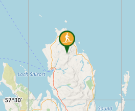
Comments
Nobody has commented on this walk yet. If you've done it then tick it off and add a comment.