
Takarunga Mount Victoria Track
North Island NZ


Menu
Takarunga / Mount Victoria Track is located in the Mount Victoria Reserve in Devonport. It's the tallest volcanic remnant on Auckland's Northshore. This short walk takes you to the summit with 360-degree views and a historic signal house, Fort Victoria and vents disguised as colourful painted mushrooms.
Lookouts
81m
Maximum Elevation
39m
Total Climb

Getting there
How do you get to the start of the walk?
Start from the main carpark on Takarunga Summit Rd or one of the other access points to the reserve.
Maps
Which maps cover the area?
Maps of Takarunga / Mount Victoria (Mount Victoria Reserve)
Route/Trail notes
A detailed description of the walk!
Loop up around the summit.
Permits/Costs
Do you need any permits? What's the cost?
Free
Other References
How can I find more info? Any guide books?
GPS Tracks
- No GPS available for this walk yet.
 1
1 1
1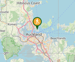
Comments
Nobody has commented on this walk yet. If you've done it then tick it off and add a comment.