


 46
46 3
3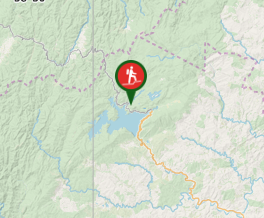
Aussie Bushwalking can keep track of your bushwalks.
Login/signup to tick this walk off.Lake Waikaremoana
North Island NZ
Menu
Trace the shoreline of Lake Waikaremoana, the ‘sea of rippling waters’, through giant podocarp rainforest, remote beaches and rugged mountains with stunning views.
Waterfalls
Lookouts
Swimming
Bird Watching
1100m
Maximum Elevation
Getting there
Waikaremoana can be approached from two directions. SH38 links Wairoa and the East Coast with the central North Island, and passes the lake and the Te Urewera Visitor Centre in Te Karetu (by the Waikaremoana Holiday Park).
The highway is a gravel surface for about 90 km between Murupara and Onepoto.
Walkers can travel to either end of the walk via water taxi. Book early.
Maps
Which maps cover the area?
Route/Trail notes
Lake Waikaremoana can be walked either from Onepoto in the south or Hopuruahine in the north. It's not a circuit track and is described here from Onepoto.
For a 3 night / 4 day trip:
- Day 1 - Onepoto to Panekire Hut
- Day 2 - Panekire Hut to Waiopaoa Hut
- Day 3 - Waiopaoa Hut to Marauiti Hut
- Day 4 - Marauiti Hut to Hopuruahine
Parking can be very busy at the Lake during the summer season. All parking is at the owners’ risk, please do not leave valuables in your cars.
Permits/Costs
Doc permits required & hut/tent costs
Other References
How can I find more info? Any guide books?
GPS Tracks
- No GPS available for this walk yet.
Comments
Nobody has commented on this walk yet. If you've done it then tick it off and add a comment.