
Queanbeyan River Loop Walk
New South Wales


Menu
A 20km walk at the southern end of Googong Dam, near Queanbeyan NSW. There are 2 options, one is to walk to Flynns Crossing and back or take the cycling route and turn the end of the walk into a slightly longer loop. An excellent walk through dry forest with a couple of river crossings to test out your boots and finding a way around one too deep to walk. Good walk for training purposes as there are regular climbs, steep and short and long and not so steep.

Getting there
London Bridge car park, London Bridge Road Burra
Maps
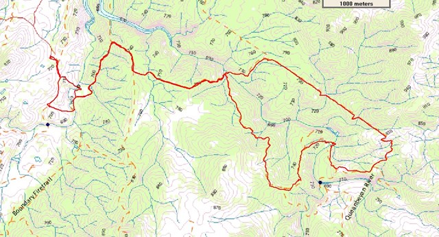
Topographic map 8726_Michelago
Route/Trail notes
The track leads uphill from the carpark, just after leaving you can choose to stay on the track or take a left turn and head across London Bridge on the way past. It is well worth it and you can continue on past the bridge and rejoin the track a bit further on. Not long after leaving here the climbs start with the most of the remaining walk being either up or down. After 4-5kms you arrive at the loop section of the walk at Gelegnite Crossing. It is nice spot to explore before choosing to head either left or right for the loop section. We chose the left track which took us across the river and along the fenceline for about 4kms at which point the track turns back towards home. This section to Flynn's Crossing has some relief from the climbing. Flynn's Crossing is quite wide and the day we walked the water was too deep to walk across without taking off our boots. We scrambled along the river bank and found a large tree across the water that we used to save getting wet feet. If you time this is a great place for lunch. Another 4kms had us back at Gelegnite Crossing. It is a big long climb out of Gelegnite Crossing but home is just 4km.
The track is promoted for mountain biking as well as walking. The walk is actually directly to Flynn's Crossing by taking the right track at Gelegnite Crossing and return the same way. We chose to follow the cycling loop.
There are picnic facitlities and toilets at the track head.
Permits/Costs
Nil required
Other References
www.tams.act.gov.au or 02 6226 3867 (Ranger Station)
GPS Tracks
- No GPS available for this walk yet.
 20
20 5
5
Comments
Nobody has commented on this walk yet. If you've done it then tick it off and add a comment.