


 13.5
13.5 3
3
Aussie Bushwalking can keep track of your bushwalks.
Login/signup to tick this walk off.Mount Sanageyama 猿投山 (Aichi Prefecture)
Japan
Menu


Sanageyama - literally monkey throwing mountain, is a nice short hike with good views over rural Aichi located in Toyota city. A good escape from Nagoya and some cool waterfalls.
Waterfalls
Lookouts
Bird Watching
Heritage Sites
Picnic Facilities
Toilets
Public Transport
629m
Maximum Elevation
Getting there
You can get to this hike either by driving or by bus. Take the bus to Sanage jinja-mae (Sanage shrine). Alternatively park your car at the Sanage shrine carpark, just be warned that there are four carparks for the shrine. The first expressly prohibits hikers from parking there, it is for people only visiting the shrine. Hikers must use the other three carparks. They fill up quickly so I'd recommend getting there early. Parking is free.
Maps
Yamap
Route/Trail notes
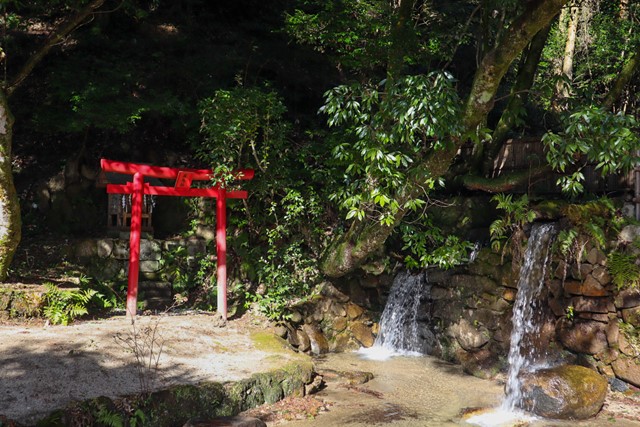
Start the hike by visiting Sanage shrine.
From the shrine, follow the road next to the shrine past the carparks. Continue on this road and it will take you to an old road covered in forest. Continue along the road and look out for signs that say 自然歩行. Continuing following this path to where the hiking track begins on a proper dirt mountain trail. Here signs will change, now look for signs that say 東の宮 which is the name of a shrine on the mountain.
The incline is slight and should be doable without much effort.
Once you reach a road, there will be a shrine (西の宮) and two paths. Look for the path that goes upwards into the forest that has a sign pointing towards 東の宮.
Continue following those signs and you will eventually reach the shrine. From the shrine, tucked away in the corner is a bridge with a small shrine pointing you towards the summit of mount Sanage (猿投山頂), follow these signs and you will get to the peak where there are bunch of park benches and places to eat lunch. It gets crowded as every man and his dog from Nagoya hikes Sanageyama on the weekend.
Follow the same way back, but when you reach the open road section where the first shrine you saw was, instead take the road. This path will take you on the seven waterfalls path. This path follows an old road next to a river. I recommend crossing the river using the bridge and taking the board walk. Keep your eyes peeled for signs that read 猿投神社 (Sanage shrine). The path will take you past some stunning farmland and residential areas before looping you back to the main shrine. Just be warned that the waterfall hike adds an extra 4kms to the hike.
After the hike, I recommend taking a dip in the nearby onsen at Sanage onsen. It's pretty g.
Permits/Costs
Nada
GPS Tracks
- No GPS available for this walk yet.
Comments
Nobody has commented on this walk yet. If you've done it then tick it off and add a comment.