


 18.5
18.5 12
12- Mt Barney via Logans Ridge and return via Gorge (Mt Barney National Park)
- Mt Barney - East Peak - Up Logan's - Down South (Mt Barney National Park)
- Mt Barney - East Peak - South Ridge (Mt Barney National Park)
- Mt Barney - East Peak - Up South-East - Down South (Mt Barney National Park)
- Mt Barney East Peak - South-East Ridge up and South Ridge down (Mt Barney National Park)
Mt Barney via Gorge and down Peasants Ridge
Mt Barney National Park
Menu

A tough hike in up the Gorge mostly off track with some challenging rock scrambling. Upon reaching Barney Saddle the trek up West Peak is reasonably challenging and shouldn't be attempted unless you have a head for heights as it is quite steep and exposed in places. After returning to the saddle if time allows the return trip up East Peak is well worth tackling as the views from the summit are unbeatable on a clear day. The trip down via Peasants Ridge is relatively straight forward but does offer a couple of interesting sections. After reaching the car park at Yellow Pinch it is about 6km to the start point by road at Lower Portals Carpark. It is preferable to have organised a car shuffle so as to avoid this at the end of a long day.
Getting there
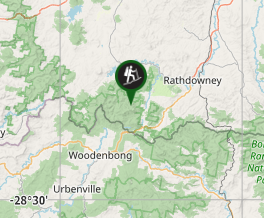
How do you get to the start of the walk? From Brisbane take Mt Lindsey Hwy past Beaudesert and Rathdowney. Turn right onto Boonah - Rathdowney Rd and travel 7kms then turn left onto Barney View - Upper Logan Rd. Reset odometer here. After 3.9km turn left at T intersection and continue to Lower Portals Rd at 7.7km. For a car shuttle continue straight for a further 3km and leave vehicle at Yellow Pinch car park. Return to Lower Portals Rd and turn left after 600m. Follow this road to end taking care over some whoop de doos and park in Lower Portals Car Park.
Maps
Which maps cover the area? Sunmap Mt Lindesay 1:25000
Route/Trail notes
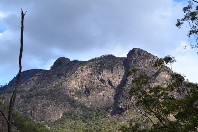
A detailed description of the walk! Take foot track from car park to Lower Portals. At the old campsite (closed for revegetion) turn left and follow a track uphill to the top of the ridgeline at which point a crossroad is reached. Left leads a hundred metres uphill to the top of a knoll where extensive views of the Mt Barney monolith are available. The track to the right is an alternative along the ridgeline to a further track that descends to the left to the campsite on the banks of Mt Barney Creek. Or head straight ahead downhill to the banks of Mt Barney Creek at which point turn right (upstream) and make your way upstream by rockhopping on either bank or through the middle until reaching Mt Barney Gorge which is a couple of hundred metres above the aforementioned campsite. A number of gorges are passed before reaching Mt Barney Gorge which can be quite easy to miss so a map and navigational skills are handy.
Upon reaching the gorge follow this all the way to Mt Barney Saddle. The gorge is steep and slippery in places with no obvious track. At times detours around steep waterfalls are recommended sometimes on the left and sometimes on the right. Take care not to inadvertantly detour up an incorrect gully during these detours. A member of my party had to be helicoptered out of this gorge about midway up back in the 80's as his father slipped and broke his leg. They had to make camp and wait for a day and a half until they were found.
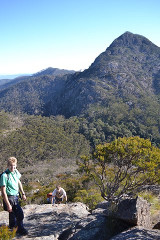
Upon reaching the saddle the old hut site is reached. This is an excellent spot for lunch with a reliable source of water on hand. We left the younger members of our party to rest and recuperate whilst we pushed on to the Rum Jungle campsite and then up to west Peak. The climb up here is sometimes marked but mostly not. It is quite steep and exposed in some sections and should not be attempted unless you are an experienced rock scrambler and have a head for heights.
Upon returning to the saddle we grabbed a quick bite to eat and then pushed on up to East Peak, a much more user friendly climb for the younger party members (14 years old). The view from the top is also much more expansive than from West Peak due to much less vegetation. After soaking in the views we descended back to the saddle and across to Rum Jungle before finding the Peasants Ridge track on the East South East edge of the clearing. This track heads uphill for a little while before descending steeply down to the Logan River Valley. After reaching a 4WD track head left and continue across a ford and eventually to Yellow Pinch Car Park.
Permits/Costs
Do you need any permits? What's the cost? Nill unless camping.
Other References
How can I find more info? Any guide books?
GPS Tracks
- No GPS available for this walk yet.
Where
Click here to load this map.
Comments