
Mt Doubletop
Main Range National Park


Menu

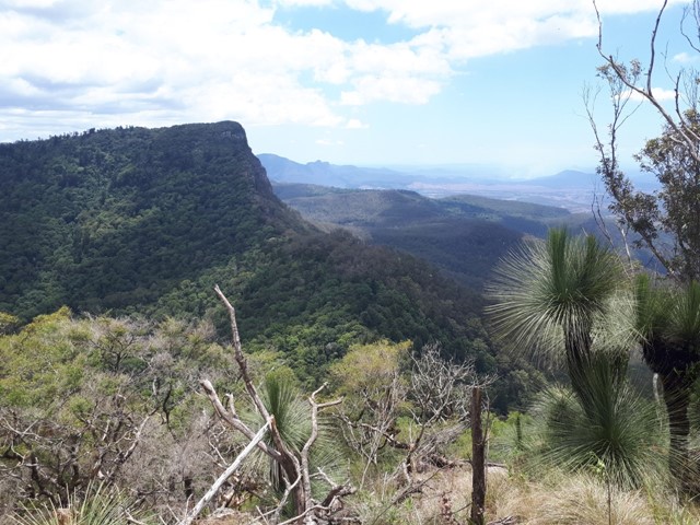

A quick but challenging walk up to one of the lesser known peaks of the Great Dividing Range with excellent views out to Moogerah and Spicers Peak. The peak is very distinctive with it's double summit, can be seen clearly when driving towards Cunninghams Gap from the East, it sits to the left of Spicers Peak.

Getting there
There are a number of ways to get to Mt Doubletop but this entry will only outline the most direct way. You want to set course for Top Swanfels Rd (which is on the backside of the range). It starts off paved then becomes dirt. Eventually it will start becoming quite steep and it would be advisable to have a 4wd, particularly after any rain. In saying that it could be doable in a 2wd with sufficient clearance. In the linked Wikiloc entry they parked below the steep part and walked up the fire road. We were in a 4wd so we went a bit further and parked at 28.127510S, 152.398450E.
Route/Trail notes
From there we walked along the old fireroad for quite a while. The road does eventually disappear then it's a mostly trackless walk to the summit. There are quite a few pink ribbons directing the way but I would definitely advise a GPS. There is a tiny bit of scrambling but nothing terribly difficult. As the name suggests the peak has a double top with 2 summits. Great views from the top and a little campsite in the saddle which also has great views. Fastest way back is the way you came, however some people do it as a circuit. Have marked the walk as hard mainly for the navigation component, because it's not overly difficult or exhausting.
Permits/Costs
No permits required.
Other References
https://www.wikiloc.com/hiking-trails/doubletop-circuit-35147269
GPS Tracks
- No GPS available for this walk yet.
 6
6 3
3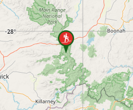
Comments