


 Boonah Ipswich Trail north section (GPX)
 19
19 7
7- Flinder’s Peak Circuit - approach from South (Ipswich - Flinders Goolman Conservation Estate)
- Flinders Peak (Ipswich - Flinders Goolman Conservation Estate)
- Sandy Creek Track (Ipswich - Flinders Goolman Conservation Estate)
- Mt Blaine Base Trail (Ipswich - Flinders Goolman Conservation Estate)
- Sandy Creek Central Ridge Track (Ipswich - Flinders Goolman Conservation Estate)
Boonah to Ipswich Trail
Ipswich - Flinders Goolman Conservation Estate
Menu
GPS Tracks
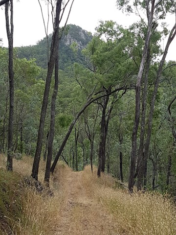
This trail forms the backbone of all trails in the Conservation Estate, and connects the two picnic areas. It caters for hiking, horse riding and recreational touring (mountain bike riding). At 38 km return, this trail becomes challenging. Experienced walkers would need to start early in the morning to complete a return trip, requiring at least a 10 to 14 hour day. Note that the conservation estate is open between the hours of 6am and 6pm. Alternatively, a 19km one way walk could be considered for those who can organise travel/accommodation arrangements at the other end. Rugged mountain scenery, views to the coast from Mt Flinders, creek crossings and diverse landscapes such as dry rainforest and heath will reward you.
No Dogs Permitted
No Camping Permitted
Eucalypt Forest
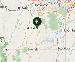
Getting there
Ipswich Boonah Rd (Off Cunningham Hwy) to Carmichaels Rd (Entry to Hardings Paddock Picnic Grounds
Maps
Access to a map for this trail is available on the Ipswich City Council website (www.ipswich.qld.gov.au)
Route/Trail notes
This walk is 19km one way and will take you approx 7hrs (one way) so make sure that someone is at the other end to pick you up. This trail is popular with Horse Riding so be wary of horses.
Permits/Costs
PLEASE NOTE THERE IS NO CAMPING ALLOWED IN THE ESTATE. Be sure to have someone pick you up at the other end.
Other References
https://www.facebook.com/BoonahIpswichTrail
GPS Tracks
Where
Click here to load this map.
Comments