


 Enoggera Pipeline Tunnel (GPX)
 4
4 90
90- Enoggera Reservoir Circuit (Brisbane Forest park D'Aguilar National Park)
- Araucaria Track (Brisbane Forest park D'Aguilar National Park)
- Holmans break (Brisbane Forest park D'Aguilar National Park)
- Corymbia Circuit (Brisbane Forest park D'Aguilar National Park)
- Curlew Ironbark Circuit (Mt. Coot-tha)
Enoggera Reservoir Tunnel
Brisbane Forest park D'Aguilar National Park
Menu
GPS Tracks
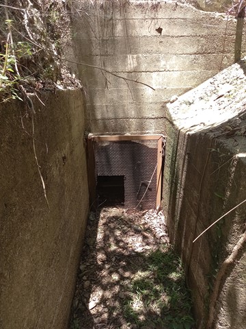


A short but rewarding walk to a piece of Brisbane's history. Built in 1928, along with an open viaduct, this tunnel moved water from Gold Creek Reservoir to Enoggera Reservoir. See https://historyoutthere.com/2018/09/23/the-secret-tunnel-to-australias-past/ for history.
Heritage Sites
Navigation Required
Eucalypt Forest
189m
Maximum Elevation
167m
Total Climb
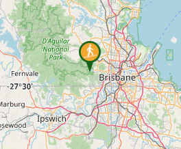
Getting there:
Drive to Highwood Rd, MtCoot-tha and park short of the end of the road -27.463709, 152.922863 .
Head to the end of Highwood Rd and enter the park.
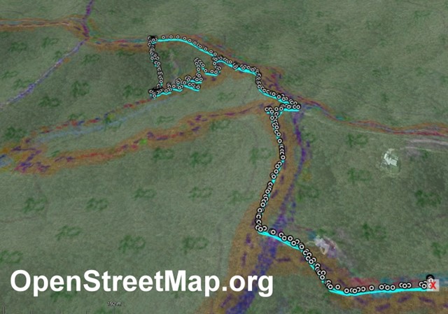
Maps: OpenstreetMap.org shows several GPS traces.
Route/Trail notes:
Head west from the end of the bitumen road, then turn right/north and go up to South Boundary Rd.
Head generally west along South Boundary Rd. From South Boundary Rd there are three options:
1. At 27.45713S 152.91672E head generally SW down the zig-zag trail. This trail is well graded and the shortest/easiest way.
2. At 27.45784S 152.91866E head generally south. This track is very steep and eroded with lots of loose rocks. A slip heading down could be quite dangerous. It was hard work going up.
3. Follow the Gold Creek Trail down then double back NE up the Tunnel Trail. This the long way around.
The tunnel is at 27.45876S 152.91704E at the bottom of the gully/valley. It's not overgrown and is easy to see.
Surprisingly, there was Optus mobile coverage at the tunnel.
Permits/Costs: Nil.
GPS Tracks
Where
Click here to load this map.
Comments