
Sharpes Creek Track
Barrington Tops National Park


Menu
A walk through rainforest in the eastern section of Barrington Tops National Park from the Gloucester River Camping Area to the top of the hill and back via the road.

Getting there
Travel south from Gloucester and turn right into Gloucester Tops Rd. This road is partly gravel and crosses a number of flood ways. The road drives straight through the camp ground. It's a fair way along, it you can't miss it.
Maps
Which maps cover the area?
Route/Trail notes
This track begins on the right, just before the Gloucester River Camping Area. It takes you first through dry rain forest, and then ascends steeply through eucalypt forest up to the roadway. Then turn left to return back to the start along the road. This is a really steep walk. You may prefer to turn back once you reach the part of the track that begins the ascent. There is a sign here that says that it's 30 minutes back to the camp ground. This would make the total walk only 3km, and take an hour.
Permits/Costs
NO cost unless Camping
Other References
How can I find more info? Any guide books?
GPS Tracks
- No GPS available for this walk yet.
 4.5
4.5 2
2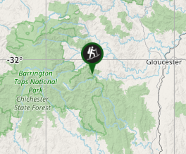
Comments